File:Philadelphia skyline from South Street Bridge January 2020 (rotate 2 degrees perspective correction crop 4-1).jpg

Yanayin wannan rigayi gani: 800 × 200 pixels. Wasu yarjejeniyoyi: 320 × 80 pixels | 640 × 160 pixels | 1,024 × 256 pixels | 3,816 × 954 pixels.
Hoton asali (pikisal 3,816 × 954, girman fayil: 1.42 MB, irin MIME: image/jpeg)
Taƙaici
| Bayani |
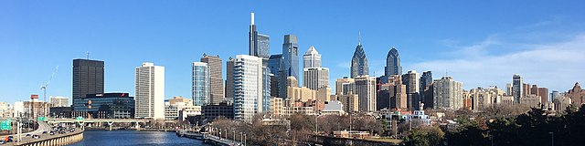
English: The skyline of Philadelphia, Pennsylvania viewed from the South Street Bridge over the Schuylkill River. If on Wikipedia, see the fully annotated version on the Wikimedia page.
|
||
| Rana | |||
| Masomi | File:Philadelphia_skyline_from_South_Street_Bridge_January_2020.jpeg | ||
| Marubucin | Dough4872; modifications and annotations by Maps and stuff (Brian W. Schaller) | ||
| Other versions |
|

.jpg)
| Camera location | | View this and other nearby images on: OpenStreetMap |
|---|
.jpg¶ms=039.946975_N_-075.186797_E_globe:Earth_type:camera_heading:69.51&language=ha)
Lasisi
This file is licensed under the Creative Commons Attribution-Share Alike 4.0 International license.
- Za ka iya:
- a raba – dan kwafa, yadawa da aika aikin
- dan maimaita – dan daukar aikin
- A karkashin wannan sharuddan
- Jinginarwa – Dole ku bada jinjina da ta dace, samar da linki zuwa lasisin, da kuma bayyana ko kunyi sauyi. Zaku iya haka ta yadda ta dace, amma ba kowace hanya ba wanda zai nuna mai-lasisin yana goyon bayan ku ba ko goyon bayan amfanin da kuke yi ba.
- Yada ahaka – Idan kuka maimaita, sabuntawa, ko kari akan wannan, dole ku bayar da gudunmuwar ku karkashin iri daya ko lasisi data dace kamar na asali.
| Annotations | This image is annotated: View the annotations at Commons |
Tarihin fayil
Ku latsa rana/lokaci ku ga fayil yadda yake a wannan lokaci
| Rana/Lokaci | Wadar sufa | Kusurwowi | Ma'aikaci | Bahasi | |
|---|---|---|---|---|---|
| na yanzu | 14:22, 27 ga Janairu, 2020 | 3,816 × 954 (1.42 MB) | Maps and stuff | User created page with UploadWizard |
Amfani da fayil
Wadannan shafi na amfani wannan fayil:
Amfanin fayil a ko'ina
Wadannan sauran wikis suna amfani da fayil din anan
- Amfani a kan ang.wikipedia.org
- Amfani a kan ar.wikipedia.org
- Amfani a kan arz.wikipedia.org
- Amfani a kan ast.wikipedia.org
- Amfani a kan br.wikipedia.org
- Amfani a kan ca.wikipedia.org
- Amfani a kan ce.wikipedia.org
- Amfani a kan ckb.wikipedia.org
- Amfani a kan cy.wikipedia.org
- Amfani a kan da.wikipedia.org
- Amfani a kan de.wikivoyage.org
- Amfani a kan diq.wikipedia.org
- Amfani a kan en.wikipedia.org
- Amfani a kan en.wikibooks.org
- Amfani a kan en.wikivoyage.org
- Amfani a kan eu.wikipedia.org
- Amfani a kan fr.wikivoyage.org
- Amfani a kan ga.wikipedia.org
- Amfani a kan gl.wikipedia.org
- Amfani a kan he.wikivoyage.org
- Amfani a kan ht.wikipedia.org
- Amfani a kan ia.wikipedia.org
- Amfani a kan ilo.wikipedia.org
- Amfani a kan incubator.wikimedia.org
- Amfani a kan it.wikipedia.org
- Amfani a kan it.wikivoyage.org
- Amfani a kan ja.wikivoyage.org
- Amfani a kan kab.wikipedia.org
- Amfani a kan lb.wikipedia.org
- Amfani a kan lld.wikipedia.org
- Amfani a kan mhr.wikipedia.org
- Amfani a kan no.wikipedia.org
- Amfani a kan ru.wikipedia.org
- Amfani a kan ru.wikinews.org
- Amfani a kan simple.wikipedia.org
- Amfani a kan sr.wikipedia.org
Duba ƙarin amfanin wannan fayil.
.jpg)
.jpg)