File:Franklingulfstream.jpg
Yanayin wannan rigayi gani: 736 × 599 pixels. Wasu yarjejeniyoyi: 295 × 240 pixels | 590 × 480 pixels | 943 × 768 pixels | 1,258 × 1,024 pixels | 2,516 × 2,048 pixels | 3,089 × 2,515 pixels.
Hoton asali (pikisal 3,089 × 2,515, girman fayil: 1.2 MB, irin MIME: image/jpeg)
| Bayani |
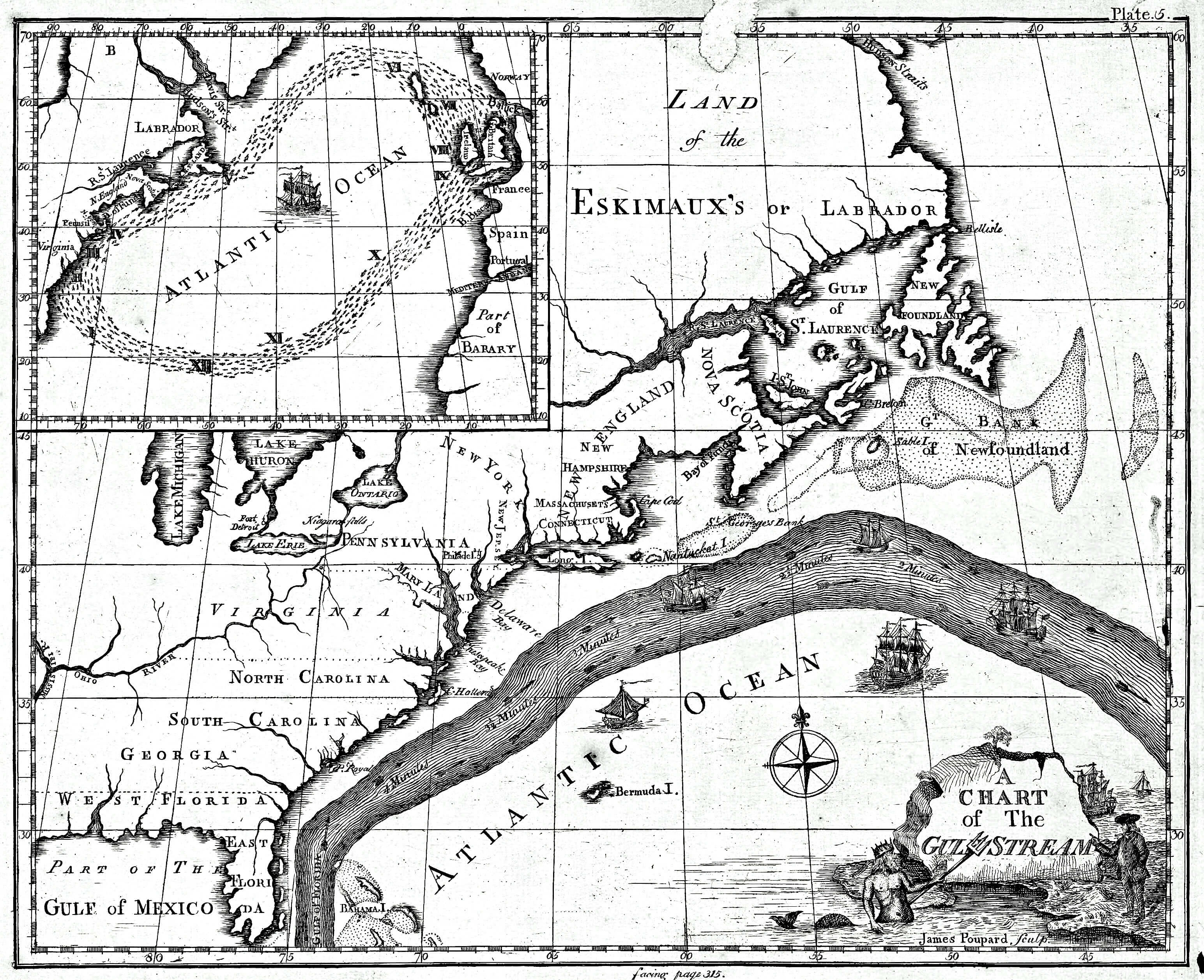
English: Earliest known map of the Gulf Stream |
| Rana | |
| Masomi |
https://www.loc.gov/resource/g9112g.ct000136/ (2018-03-20)
|
| Marubucin | Library of Congress/Benjamin Franklin |
| Other versions |
Cropped version uploaded in September 2016: |
Lasisi
This image is in the public domain because it contains materials that originally came from the U.S. National Oceanic and Atmospheric Administration, taken or made as part of an employee's official duties.
|
Original upload log
The original description page was here. All following user names refer to en.wikipedia.
- 2008-09-21 12:47 Thegreatdr 540×433× (79994 bytes) {{Information |Description=Earliest known map of the Gulf Stream |Source=http://oceanexplorer.noaa.gov/library/readings/hires/gulf_stream_map.jpg |Date=2008-09-21 |Author=Library of Congress/Benjamin Franklin |Permission= |other_versions= }}
Tarihin fayil
Ku latsa rana/lokaci ku ga fayil yadda yake a wannan lokaci
| Rana/Lokaci | Wadar sufa | Kusurwowi | Ma'aikaci | Bahasi | |
|---|---|---|---|---|---|
| na yanzu | 17:11, 25 ga Afirilu, 2021 | | 3,089 × 2,515 (1.2 MB) | RCraig09 | Version 4: reduced file size at tinyjpg.com |
| 20:32, 20 ga Maris, 2018 |  | 3,089 × 2,515 (2.45 MB) | RCraig09 | Updated version from Library of Congress in response to note on talk page about watermark asserted to be present in earlier uploads. Source (2019-03-20): https://www.loc.gov/resource/g9112g.ct000136/ | |
| 20:39, 26 ga Maris, 2012 |  | 5,868 × 4,761 (5.07 MB) | ServiceAT | Replaced low resolution image by higher resolution scan of same original. | |
| 10:37, 7 ga Yuli, 2009 |  | 540 × 433 (78 KB) | Nk | {{Information |Description={{en|Earliest known map of the Gulf Stream}} |Source=Transferred from [http://en.wikipedia.org en.wikipedia]<br/> (Original text : ''http://oceanexplorer.noaa.gov/library/readings/hires/gulf_stream_map.jpg'') |Date={{Date|2008|0 |
Amfani da fayil
Wadannan shafi na amfani wannan fayil:
Amfanin fayil a ko'ina
Wadannan sauran wikis suna amfani da fayil din anan
- Amfani a kan ast.wikipedia.org
- Amfani a kan ba.wikipedia.org
- Amfani a kan bg.wikipedia.org
- Amfani a kan bs.wikipedia.org
- Amfani a kan ca.wikipedia.org
- Amfani a kan en.wikipedia.org
- Amfani a kan es.wikipedia.org
- Amfani a kan eu.wikipedia.org
- Amfani a kan fi.wikipedia.org
- Amfani a kan fr.wikipedia.org
- Amfani a kan it.wikipedia.org
- Amfani a kan kn.wikipedia.org
- Amfani a kan mk.wikipedia.org
- Amfani a kan ms.wikipedia.org
- Amfani a kan nn.wikipedia.org
- Amfani a kan no.wikipedia.org
- Amfani a kan ru.wikipedia.org
- Amfani a kan si.wikipedia.org
- Amfani a kan sr.wikipedia.org
- Amfani a kan tr.wikipedia.org
- Amfani a kan uk.wikipedia.org
- Amfani a kan vi.wikipedia.org
- Amfani a kan zh.wikipedia.org