Fayil:Canton1860.jpg

Yanayin wannan rigayi gani: 800 × 457 pixels. Wasu yarjejeniyoyi: 320 × 183 pixels | 640 × 366 pixels | 1,024 × 585 pixels | 1,280 × 731 pixels | 2,560 × 1,462 pixels | 11,680 × 6,672 pixels.
Hoton asali (pikisal 11,680 × 6,672, girman fayil: 11.72 MB, irin MIME: image/jpeg)
| Warning | The original file is very high-resolution. It might not load properly or could cause your browser to freeze when opened at full size. |
|---|
Taƙaici
{{Map
|Description =
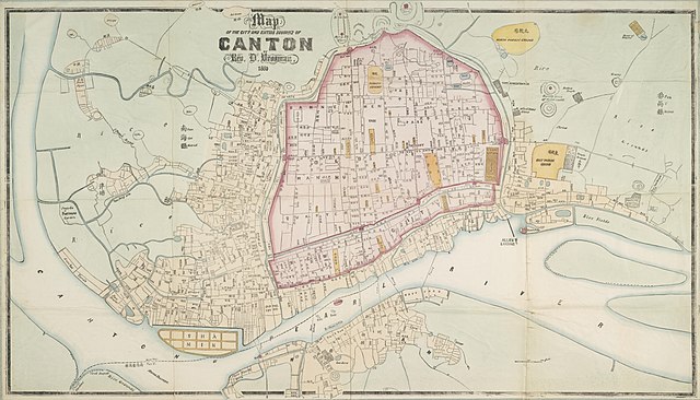
English: "Map of the City and Entire Suburbs of Canton in 1860 by Rev. D. Vrooman", an updating of Vrooman's 1855 map of the city, incorporating the destruction of the Thirteen Factories, the erection of Shamian, and minor adjustments to his prospective map of the city following its opening to foreign visitors following the treaties of Tianjin and Beijing.
Three forts shown L-R are:} Rouge Fort, Dutch Folly, and French Folly.}
中文(简体):广州市1860年地图,藏于澳洲国家图书馆。
中文(繁體):廣州市1860年地圖,藏於澳洲國家圖書館。
Lasisi
|
This work is in the public domain in its country of origin and other countries and areas where the copyright term is the author's life plus 100 years or fewer. | |
| This file has been identified as being free of known restrictions under copyright law, including all related and neighboring rights. | |
Tarihin fayil
Ku latsa rana/lokaci ku ga fayil yadda yake a wannan lokaci
| Rana/Lokaci | Wadar sufa | Kusurwowi | Ma'aikaci | Bahasi | |
|---|---|---|---|---|---|
| na yanzu | 14:25, 17 ga Janairu, 2018 | | 11,680 × 6,672 (11.72 MB) | User-duck | Cropped using CropTool with lossless mode. |
| 10:34, 24 ga Augusta, 2011 |  | 11,952 × 7,536 (13.97 MB) | Gzdavidwong | {{Information |Description ={{en|1=Maps of Canton City in 1860.}} {{zh-hans|1=广州市1860年地图。}} {{zh-hant|1=廣州市1860年地圖。}} |Source ={{own}} |Author =Gzdavidwong |Date =1860 |Permissi |
Amfani da fayil
Wadannan shafi na amfani wannan fayil:
Amfanin fayil a ko'ina
Wadannan sauran wikis suna amfani da fayil din anan
- Amfani a kan en.wikipedia.org
- Amfani a kan fr.wikipedia.org
- Amfani a kan ja.wikipedia.org
- Amfani a kan mai.wikipedia.org
- Amfani a kan ru.wikipedia.org
- Amfani a kan www.wikidata.org
- Amfani a kan zh-yue.wikipedia.org
- Amfani a kan zh.wikipedia.org