File:WholeRegionSevres.gif
Yanayin wannan rigayi gani: 800 × 519 pixels. Wasu yarjejeniyoyi: 320 × 208 pixels | 640 × 415 pixels | 1,024 × 664 pixels | 1,280 × 830 pixels | 2,560 × 1,660 pixels | 4,553 × 2,953 pixels.
Hoton asali (pikisal 4,553 × 2,953, girman fayil: 260 KB, irin MIME: image/gif)
Taƙaici
| Bayani |
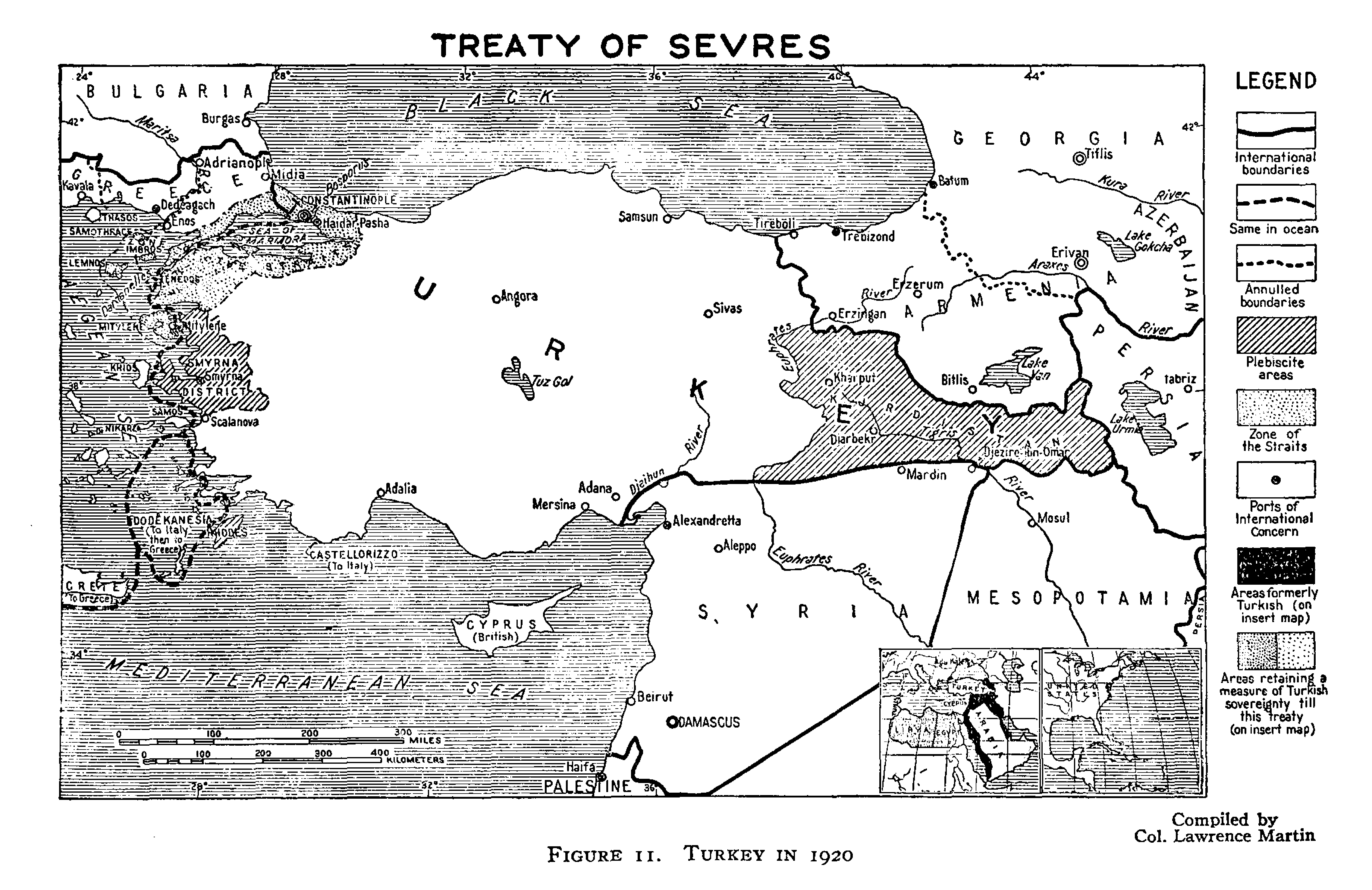
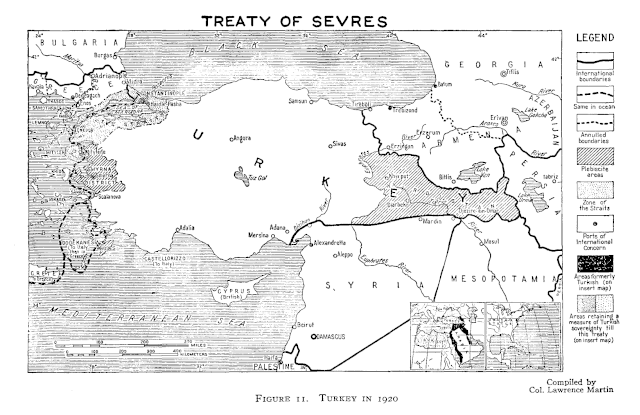
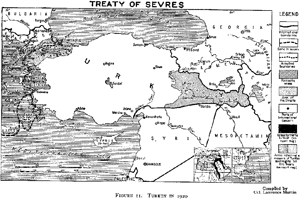
English: An original map from 1920 illustrating the Treaty of Sevres region. |
| Rana | |
| Masomi | http://www.gwpda.org/gifs/turk1920.gif |
| Marubucin | Lt. Colonel Lawrence Martin. Geographer of the Institute of Politics at Williamstown, MA, 1921-27 |
Lasisi
This media file is in the public domain in the United States. This applies to U.S. works where the copyright has expired, often because its first publication occurred prior to January 1, 1929, and if not then due to lack of notice or renewal. See this page for further explanation.
|
 | |
 |
This image might not be in the public domain outside of the United States; this especially applies in the countries and areas that do not apply the rule of the shorter term for US works, such as Canada, Mainland China (not Hong Kong or Macao), Germany, Mexico, and Switzerland. The creator and year of publication are essential information and must be provided. See Wikipedia:Public domain and Wikipedia:Copyrights for more details.
|
Tarihin fayil
Ku latsa rana/lokaci ku ga fayil yadda yake a wannan lokaci
| Rana/Lokaci | Wadar sufa | Kusurwowi | Ma'aikaci | Bahasi | |
|---|---|---|---|---|---|
| na yanzu | 07:23, 30 ga Yuni, 2021 | | 4,553 × 2,953 (260 KB) | Zero0000 | minor adjustments |
| 07:07, 30 ga Yuni, 2021 |  | 2,277 × 1,477 (366 KB) | Zero0000 | Higher resolution | |
| 18:12, 30 ga Yuni, 2012 |  | 1,034 × 692 (33 KB) | Infestor |
Amfani da fayil
Babu shafuka da suke amfani da fayil din nan.
Amfanin fayil a ko'ina
Wadannan sauran wikis suna amfani da fayil din anan
- Amfani a kan ar.wikipedia.org
- Amfani a kan azb.wikipedia.org
- Amfani a kan az.wikipedia.org
- Amfani a kan cy.wikipedia.org
- Amfani a kan el.wikipedia.org
- Amfani a kan en.wikipedia.org
- Amfani a kan et.wikipedia.org
- Amfani a kan he.wikipedia.org
- Amfani a kan hy.wikipedia.org
- Amfani a kan ia.wikipedia.org
- Amfani a kan ja.wikipedia.org
- Amfani a kan ko.wikipedia.org
- Amfani a kan lv.wikipedia.org
- Amfani a kan mk.wikipedia.org
- Amfani a kan pnb.wikipedia.org
- Amfani a kan ru.wikipedia.org
- Amfani a kan tr.wikipedia.org
- Amfani a kan uk.wikipedia.org
- Amfani a kan ur.wikipedia.org
- Amfani a kan www.wikidata.org