File:West Asia Köppen Map.png
Yanayin wannan rigayi gani: 502 × 599 pixels. Wasu yarjejeniyoyi: 201 × 240 pixels | 402 × 480 pixels | 990 × 1,182 pixels.
Hoton asali (pikisal 990 × 1,182, girman fayil: 511 KB, irin MIME: image/png)
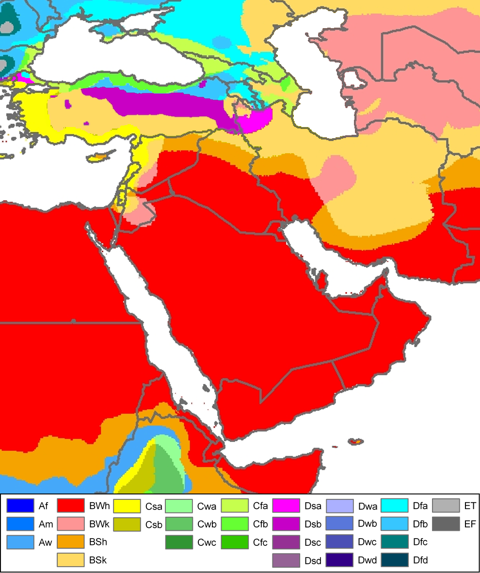
| Peel, M. C. and Finlayson, B. L. and McMahon, T. A. (2007). "Updated world map of the Köppen-Geiger climate classification". Hydrol. Earth Syst. Sci. 11: 1633-1644. ISSN 1027-5606. |
Legend
Taƙaici
| Bayani | Climate map of (South)west-Asia and adjacent areas (from the "Updated world map of the Köppen-Geiger climate classification"). |
| Rana | |
| Masomi | Hydrology and Earth System Sciences: "Updated world map of the Köppen-Geiger climate classification" (Supplement) - Original file was a JPG-file, this file is has been converted to a PNG-file, without extra modifications, by me (Jeroen). |
| Marubucin |
Peel, M. C., Finlayson, B. L., and McMahon, T. A. (University of Melbourne) |
| Izini (Sake amfani da wannan fayil) |

|
This meteorology image could be re-created using vector graphics as an SVG file. This has several advantages; see Commons:Media for cleanup for more information. If an SVG form of this image is available, please upload it and afterwards replace this template with
{{vector version available|new image name}}.
It is recommended to name the SVG file “West Asia Köppen Map.svg”—then the template Vector version available (or Vva) does not need the new image name parameter. |
Related maps
User Jeroenvrp made for these continents and areas a cropped and resized version:
- Africa Köppen Map.png
- Asia Köppen Map.png
- Australia-Oceania Köppen Map.png
- Europe Köppen Map.png
- North America Köppen Map.png
- Russia Köppen Map.png
- South America Köppen Map.png
- West Asia Köppen Map.png.
User LordToran made from the same data these maps:
- Klimagürtel-der-erde-eisklima.png
- Klimagürtel-der-erde-gemäßigte-zone.png
- Klimagürtel-der-erde-polargebiete.png
- Klimagürtel-der-erde-subtropen.png
- Klimagürtel-der-erde-tropen.png
- Klimagürtel-der-erde-tundra.png
- Klimagürtel-der-erde-warmgemäßigte-zone.png
- Klimagürtel-der-erde.png
- Klimagürtel-der-erde.svg
- Klimate-humidität.png
- Köppen-geiger-hessd-2007.svg
- Köppen-vereinfacht.svg
- Trockenklimate.png
Lasisi
Wannan fayil ɗin an bada lasisin shi ƙarƙashin Creative Commons Attribution-Share Alike 3.0 Unported lasisi.
- Za ka iya:
- a raba – dan kwafa, yadawa da aika aikin
- dan maimaita – dan daukar aikin
- A karkashin wannan sharuddan
- Jinginarwa – Dole ku bada jinjina da ta dace, samar da linki zuwa lasisin, da kuma bayyana ko kunyi sauyi. Zaku iya haka ta yadda ta dace, amma ba kowace hanya ba wanda zai nuna mai-lasisin yana goyon bayan ku ba ko goyon bayan amfanin da kuke yi ba.
- Yada ahaka – Idan kuka maimaita, sabuntawa, ko kari akan wannan, dole ku bayar da gudunmuwar ku karkashin iri daya ko lasisi data dace kamar na asali.
Tarihin fayil
Ku latsa rana/lokaci ku ga fayil yadda yake a wannan lokaci
| Rana/Lokaci | Wadar sufa | Kusurwowi | Ma'aikaci | Bahasi | |
|---|---|---|---|---|---|
| na yanzu | 12:57, 21 Nuwamba, 2016 | | 990 × 1,182 (511 KB) | Pandakekok9 | Transparent |
| 12:23, 13 ga Maris, 2011 |  | 990 × 1,182 (543 KB) | Maphobbyist | Painted the Caspian Sea as white as it should have been, because the Köppen system is based on the concept that climate types are correlated with the natural vegetation. Thus with Köppen, climate zone boundaries have been selected with vegetation distri | |
| 23:01, 12 Oktoba 2007 |  | 990 × 1,182 (507 KB) | Jeroen | Citation: '''Peel, M. C., Finlayson, B. L., and McMahon, T. A.: Updated world map of the Köppen-Geiger climate classification, Hydrol. Earth Syst. Sci., 11, 1633-1644, 2007.''' {{Information |Description= Climate map of North-America (from the "[[:Ima |
Amfani da fayil
Wadannan shafi na amfani wannan fayil:
Amfanin fayil a ko'ina
Wadannan sauran wikis suna amfani da fayil din anan
- Amfani a kan af.wikipedia.org
- Amfani a kan ar.wikipedia.org
- Amfani a kan de.wikipedia.org
- Amfani a kan en.wikipedia.org
- Amfani a kan eo.wikipedia.org
- Amfani a kan es.wikipedia.org
- Amfani a kan es.wikibooks.org
- Amfani a kan eu.wikipedia.org
- Amfani a kan fy.wikipedia.org
- Amfani a kan hy.wikipedia.org
- Amfani a kan it.wikipedia.org
- Amfani a kan ja.wikipedia.org
- Amfani a kan ja.wikibooks.org
- Amfani a kan nl.wikipedia.org
- Amfani a kan nn.wikipedia.org
- Amfani a kan oc.wikipedia.org
- Amfani a kan ro.wikipedia.org
- Amfani a kan sl.wikipedia.org
- Amfani a kan sr.wikipedia.org
- Amfani a kan te.wikipedia.org
- Amfani a kan th.wikipedia.org
- Amfani a kan uk.wikipedia.org
- Amfani a kan vi.wikipedia.org