File:Uruguay T2.png

Yanayin wannan rigayi gani: 527 × 599 pixels. Wasu yarjejeniyoyi: 211 × 240 pixels | 422 × 480 pixels | 691 × 786 pixels.
Hoton asali (pikisal 691 × 786, girman fayil: 1.18 MB, irin MIME: image/png)
Taƙaici
| Bayani |
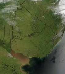
Español: Foto de Uruguay tomada desde satélite. Se aprecian claramente los límites con Brasil y Argentina, y el Río de la Plata al sur.
English: Photo of Uruguay taken from satellite, where the limits with Brazil and Argentina are clearly appreciated, as well as the Río de la Plata to the south. |
| Rana | |
| Masomi | http://visibleearth.nasa.gov/view_rec.php?id=4817 |
| Marubucin | Jeff Schmaltz, MODIS Rapid Response Team, NASA/GSFC |
Lasisi
| This file is in the public domain in the United States because it was solely created by NASA. NASA copyright policy states that "NASA material is not protected by copyright unless noted". (See Template:PD-USGov, NASA copyright policy page or JPL Image Use Policy.) | ||
 |
Warnings:
|
Tarihin fayil
Ku latsa rana/lokaci ku ga fayil yadda yake a wannan lokaci
| Rana/Lokaci | Wadar sufa | Kusurwowi | Ma'aikaci | Bahasi | |
|---|---|---|---|---|---|
| na yanzu | 04:11, 29 Nuwamba, 2004 | | 691 × 786 (1.18 MB) | Tano4595 | Uruguay_satelite |
Amfani da fayil
Babu shafuka da suke amfani da fayil din nan.
Amfanin fayil a ko'ina
Wadannan sauran wikis suna amfani da fayil din anan
- Amfani a kan af.wikipedia.org
- Amfani a kan als.wikipedia.org
- Amfani a kan an.wikipedia.org
- Amfani a kan ar.wikipedia.org
- Amfani a kan ast.wikipedia.org
- Amfani a kan azb.wikipedia.org
- Amfani a kan ba.wikipedia.org
- Amfani a kan bg.wikipedia.org
- Amfani a kan ca.wikipedia.org
- Amfani a kan cs.wikipedia.org
- Amfani a kan da.wikipedia.org
- Amfani a kan de.wikipedia.org
- Amfani a kan el.wikipedia.org
- Amfani a kan en.wikipedia.org
- Amfani a kan en.wikibooks.org
- Amfani a kan eo.wikipedia.org
- Amfani a kan es.wikipedia.org
- Amfani a kan eu.wikipedia.org
- Amfani a kan fr.wikipedia.org
- Amfani a kan gcr.wikipedia.org
- Amfani a kan hi.wikipedia.org
- Amfani a kan hr.wikipedia.org
- Amfani a kan hu.wikipedia.org
- Amfani a kan hy.wikipedia.org
- Amfani a kan hyw.wikipedia.org
- Amfani a kan is.wikipedia.org
- Amfani a kan it.wikipedia.org
- Amfani a kan ku.wikipedia.org
- Amfani a kan la.wikipedia.org
- Amfani a kan li.wikipedia.org
- Amfani a kan lv.wikipedia.org
- Amfani a kan ms.wikipedia.org
- Amfani a kan mt.wikipedia.org
- Amfani a kan oc.wikipedia.org
- Amfani a kan os.wikipedia.org
- Amfani a kan pcd.wikipedia.org
- Amfani a kan pl.wikipedia.org
Duba ƙarin amfanin wannan fayil.