File:UN Palestine Partition Versions 1947.jpg

Hoton asali (pikisal 1,370 × 2,838, girman fayil: 1.46 MB, irin MIME: image/jpeg)
Taƙaici
| Bayani |
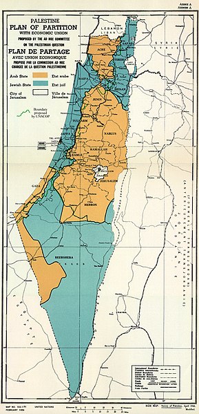
English: February 1956 Map of UN Partition Plan for Palestine, adopted 29 Nov 1947, with boundary of previous UNSCOP partition plan added in green. العربية: خريطة رسمية بعد قرار الأمم المتحدة بتاريخ 29 نوفمبر 1947م بتقسيم فلسطين إلى دولة عربية ويهودية وتحويل القدس لمدينة دولية. |
| Rana | |
| Masomi | m0103_1b.gif on PLAN OF PARTITION is from UNGA Resolution 181 (27 Nov 1947). Overdrawn UNSCOP boundary is from United Nations Special Committee on Palestine, Report to the General Assembly, 3 Sep 1947, Volume II, A/364, Add. 1. |
| Marubucin | Zero0000A/RES/181(II) |
| Other versions |
.jpg)
.jpg)
.jpg)
.jpg)
Copyright status of map:
| This image is a map derived from a United Nations map.
Unless stated otherwise, UN maps are to be considered in the public domain. This applies worldwide. UN maps are, in principle, open source material and you can use them in your work or for making your own map. UN requests however that you delete the UN name, logo and reference number upon any modification to the map. Content of your map will be your responsibility. You can state in your publication, if you wish, something like: based on UN map … (map name, map number, revision number and date). See: Geospatial Information Section. And: Geospatial, location data for a better world. |
 |
Lasisi
- Za ka iya:
- a raba – dan kwafa, yadawa da aika aikin
- dan maimaita – dan daukar aikin
- A karkashin wannan sharuddan
- Jinginarwa – Dole ku bada jinjina da ta dace, samar da linki zuwa lasisin, da kuma bayyana ko kunyi sauyi. Zaku iya haka ta yadda ta dace, amma ba kowace hanya ba wanda zai nuna mai-lasisin yana goyon bayan ku ba ko goyon bayan amfanin da kuke yi ba.
- Yada ahaka – Idan kuka maimaita, sabuntawa, ko kari akan wannan, dole ku bayar da gudunmuwar ku karkashin iri daya ko lasisi data dace kamar na asali.

|
This historical map image could be re-created using vector graphics as an SVG file. This has several advantages; see Commons:Media for cleanup for more information. If an SVG form of this image is available, please upload it and afterwards replace this template with
{{vector version available|new image name}}.
It is recommended to name the SVG file “UN Palestine Partition Versions 1947.svg”—then the template Vector version available (or Vva) does not need the new image name parameter. |


Tarihin fayil
Ku latsa rana/lokaci ku ga fayil yadda yake a wannan lokaci
| Rana/Lokaci | Wadar sufa | Kusurwowi | Ma'aikaci | Bahasi | |
|---|---|---|---|---|---|
| na yanzu | 12:07, 10 ga Augusta, 2013 | | 1,370 × 2,838 (1.46 MB) | Zero0000 | User created page with UploadWizard |
Amfani da fayil
Wadannan shafi na amfani wannan fayil:
Amfanin fayil a ko'ina
Wadannan sauran wikis suna amfani da fayil din anan
- Amfani a kan ar.wikipedia.org
- Amfani a kan arz.wikipedia.org
- Amfani a kan azb.wikipedia.org
- Amfani a kan az.wikipedia.org
- Amfani a kan bg.wikipedia.org
- Amfani a kan bn.wikipedia.org
- Amfani a kan cdo.wikipedia.org
- Amfani a kan cy.wikipedia.org
- Amfani a kan de.wikipedia.org
- Amfani a kan el.wikipedia.org
- Amfani a kan en.wikipedia.org
- 1948 Arab–Israeli War
- United Nations Partition Plan for Palestine
- Talk:United Nations Partition Plan for Palestine
- International zone
- International city
- Israel
- Arab localities in Israel
- Template talk:Largest cities of Israel
- Talk:1947–1948 civil war in Mandatory Palestine/Archive 2
- Wikipedia:Editor assistance/Requests/Archive 122
- Talk:Israel/Archive 47
- Talk:Israel/Archive 49
- November 1947
- Talk:Jerusalem/Archive 25
- User:Falcaorib
- Talk:Religion in Israel/Archive 1
- Nakba
- Wikipedia talk:Noticeboard for India-related topics/Archive 74
- User:Skingames2012/sandbox
- Amfani a kan es.wikipedia.org
- Amfani a kan et.wikipedia.org
- Amfani a kan eu.wikipedia.org
- Amfani a kan fa.wikipedia.org
- Amfani a kan fi.wikipedia.org
- Amfani a kan fr.wikipedia.org
Duba ƙarin amfanin wannan fayil.