File:Seto Inland Sea satellite.jpg

Yanayin wannan rigayi gani: 800 × 544 pixels. Wasu yarjejeniyoyi: 320 × 218 pixels | 640 × 435 pixels | 1,024 × 696 pixels.
Hoton asali (pikisal 1,024 × 696, girman fayil: 242 KB, irin MIME: image/jpeg)
| Bayani |
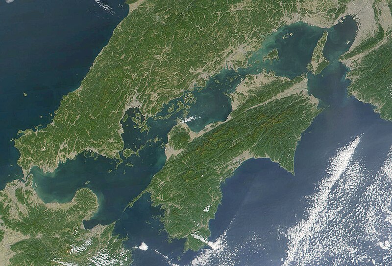
日本語: 瀬戸内海 Seto-naikai
Deutsch: Die Seto-Inlandsee ist ein Binnenmeer das die japanischen Inseln Honshū, Shikoku und Kyūshū voneinander trennt.
English: Formally named the Seto Inland Sea, the Inland Sea is the body of water separating Honshū, Shikoku, two of the main islands of Japan, and Kyūshū. |
| Rana | |
| Masomi | Cropped from: http://visibleearth.nasa.gov/view_rec.php?id=2206 |
| Marubucin | Jacques Descloitres, MODIS Land Rapid Response Team, NASA/GSFC |
| This file is in the public domain in the United States because it was solely created by NASA. NASA copyright policy states that "NASA material is not protected by copyright unless noted". (See Template:PD-USGov, NASA copyright policy page or JPL Image Use Policy.) | ||
 |
Warnings:
|
Tarihin fayil
Ku latsa rana/lokaci ku ga fayil yadda yake a wannan lokaci
| Rana/Lokaci | Wadar sufa | Kusurwowi | Ma'aikaci | Bahasi | |
|---|---|---|---|---|---|
| na yanzu | 21:21, 22 Nuwamba, 2004 | | 1,024 × 696 (242 KB) | Tsui | Japan, the Seto inland-lake |
Amfani da fayil
Babu shafuka da suke amfani da fayil din nan.
Amfanin fayil a ko'ina
Wadannan sauran wikis suna amfani da fayil din anan
- Amfani a kan en.wikipedia.org
- Amfani a kan fr.wikipedia.org
- Amfani a kan it.wikivoyage.org
- Amfani a kan ja.wikipedia.org
- Amfani a kan ja.wikibooks.org
- Amfani a kan ko.wikipedia.org
- Amfani a kan pl.wiktionary.org
- Amfani a kan tr.wikipedia.org
- Amfani a kan www.wikidata.org
- Amfani a kan wuu.wikipedia.org
- Amfani a kan zh-classical.wikipedia.org
- Amfani a kan zh-min-nan.wikipedia.org
- Amfani a kan zh.wikipedia.org