File:New York state geographic map-en.svg

Size of this PNG preview of this SVG file: 800 × 569 pixels. Wasu yarjejeniyoyi: 320 × 228 pixels | 640 × 455 pixels | 1,024 × 729 pixels | 1,280 × 911 pixels | 2,560 × 1,821 pixels | 2,811 × 2,000 pixels.
Hoton asali (Fayil kin SVG, saƙar fikisal 2,811 x 2,000, girman fayil: 18.34 MB)
Taƙaici
| Description |
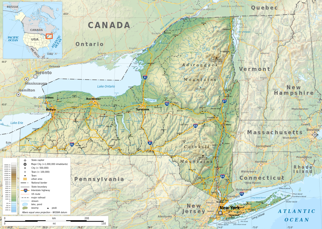
English: Geographic map of New York state in English. Geographic limits of the map:
|
| Rana | |
| Masomi |
Aikin na
|
| Maƙirƙiri | |
| Izini (Sake amfani da wannan fayil) |
Any use of this map is subject of the license(s) stated below with the condition that you credit (Wikimedia Commons user: Ikonact) as the author . A message with a reply address would also be greatly appreciated. |
| Georeferencing | If inappropriate please set warp_status = skip to hide. |
|

|
This SVG file contains embedded text that can be translated into your language, using any capable SVG editor, text editor or the SVG Translate tool. For more information see: About translating SVG files. |
Lasisi
| This work contains information from OpenStreetMap, which is made available under the Open Database License (ODbL).
The ODbL does not require any particular license for maps produced from ODbL data. Prior to 1 August 2020, map tiles produced by the OpenStreetMap Foundation were licensed under the CC-BY-SA-2.0 license. Maps produced by other people may be subject to other licences. |
I, the copyright holder of this work, hereby publish it under the following license:
This file is licensed under the Creative Commons Attribution-Share Alike 4.0 International license.
- Za ka iya:
- a raba – dan kwafa, yadawa da aika aikin
- dan maimaita – dan daukar aikin
- A karkashin wannan sharuddan
- Jinginarwa – Dole ku bada jinjina da ta dace, samar da linki zuwa lasisin, da kuma bayyana ko kunyi sauyi. Zaku iya haka ta yadda ta dace, amma ba kowace hanya ba wanda zai nuna mai-lasisin yana goyon bayan ku ba ko goyon bayan amfanin da kuke yi ba.
- Yada ahaka – Idan kuka maimaita, sabuntawa, ko kari akan wannan, dole ku bayar da gudunmuwar ku karkashin iri daya ko lasisi data dace kamar na asali.
Tarihin fayil
ku Latsa rana/lokaci ku ga fayil yadda yake a wannan lokaci
| Rana/Lokaci | Wadar sufa | Kusurwowi | Ma'aikaci | Bahasi | |
|---|---|---|---|---|---|
| na yanzu | 12:15, 2 Nuwamba, 2023 | | 2,811 × 2,000 (18.34 MB) | Ikonact | corrected some typos in names // Editing SVG source code using c:User:Rillke/SVGedit.js |
| 10:22, 14 Oktoba 2019 |  | 2,811 × 2,000 (18.41 MB) | Ikonact | better dealing with fall back font | |
| 21:19, 12 Oktoba 2019 |  | 2,811 × 2,000 (20.53 MB) | Ikonact | + fall back font, more towns and islands, provinces | |
| 23:33, 11 Oktoba 2019 |  | 2,811 × 2,000 (20.47 MB) | Ikonact | error corrected | |
| 23:23, 11 Oktoba 2019 |  | 2,811 × 2,000 (20.47 MB) | Ikonact | river and lake names added | |
| 21:58, 8 Oktoba 2019 |  | 2,811 × 2,000 (20.33 MB) | Ikonact | some improvements, roads and cities in Canada | |
| 07:40, 22 Satumba 2019 |  | 2,811 × 2,000 (14.39 MB) | Ikonact | small corrections | |
| 20:49, 21 Satumba 2019 |  | 2,811 × 2,000 (14.39 MB) | Ikonact | + road names | |
| 20:23, 21 Satumba 2019 |  | 2,811 × 2,000 (14.31 MB) | Ikonact | +names | |
| 22:01, 20 Satumba 2019 |  | 2,811 × 2,000 (15.37 MB) | Ikonact | == {{int:filedesc}} == {{Information |description={{en|1=Geographic map of New York state in English. Geographic limits of the map:}} *N: 45.30° N *S: 40.30° N *W: 80.20° W *E: 71.00° W Albers equal area projection; WGS 84 datum |date=2019-09-21 |source={{own}} *Sources of data:<br/> **Topography: ETOPO1 (public domain);<br/> **Public domain data provided by the National Atlas of the United States of America;<br/> *Tool:<br/> **The map is created with Octave scripts d... |
Amfani da fayil
Wadannan shafi na amfani wannan fayil:
Amfanin fayil a ko'ina
Wadannan sauran wikis suna amfani da fayil din anan
- Amfani a kan af.wikipedia.org
- Amfani a kan ang.wikipedia.org
- Amfani a kan az.wikipedia.org
- Amfani a kan be.wikipedia.org
- Amfani a kan bg.wikipedia.org
- Amfani a kan bn.wikipedia.org
- Amfani a kan ca.wikipedia.org
- Amfani a kan en.wikipedia.org
- Amfani a kan eo.wikipedia.org
- Amfani a kan fr.wikipedia.org
- Amfani a kan ga.wikipedia.org
- Amfani a kan gl.wikipedia.org
- Amfani a kan hu.wikipedia.org
- Amfani a kan hy.wikipedia.org
- Amfani a kan id.wikipedia.org
- Amfani a kan lt.wikipedia.org
- Amfani a kan mhr.wikipedia.org
- Amfani a kan ml.wikipedia.org
- Amfani a kan os.wikipedia.org
- Amfani a kan pcd.wikipedia.org
- Amfani a kan pl.wikipedia.org
- Amfani a kan sh.wikipedia.org
- Amfani a kan tg.wikipedia.org
- Amfani a kan tr.wikipedia.org
- Amfani a kan tt.wikipedia.org
- Amfani a kan uk.wikipedia.org
- Amfani a kan www.wikidata.org