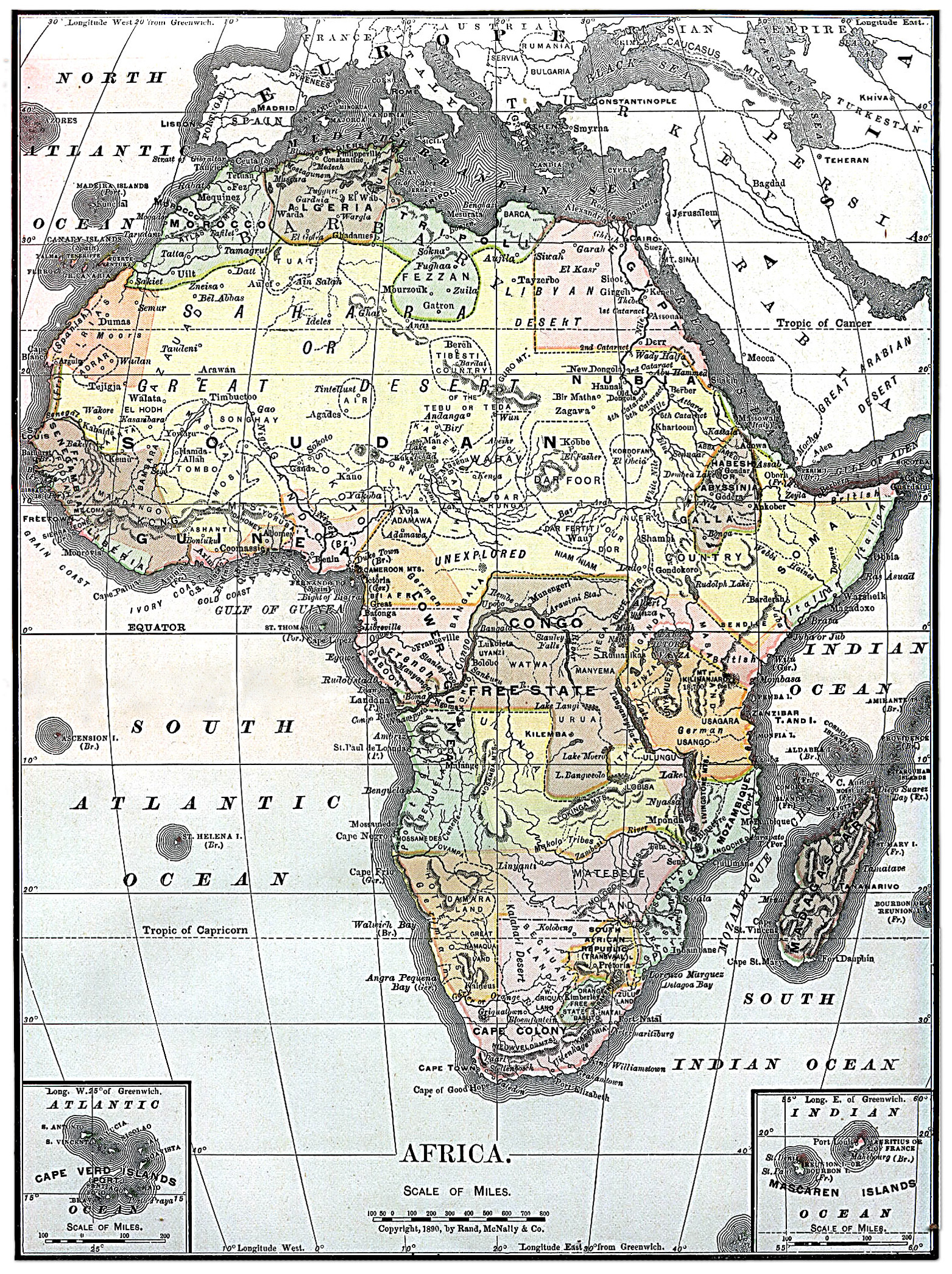
File:Map of Africa from Encyclopaedia Britannica 1890.jpg
Hoton asali (pikisal 1,563 × 2,090, girman fayil: 2.07 MB, irin MIME: image/jpeg)
Taƙaici
Lasisi
|
This work is in the public domain in its country of origin and other countries and areas where the copyright term is the author's life plus 70 years or fewer.
| |
| This file has been identified as being free of known restrictions under copyright law, including all related and neighboring rights. | |
| This image comes from the 13th edition of the Encyclopædia Britannica or earlier. The copyrights for that book have expired in the United States because the book was first published in the US with the publication occurring before January 1, 1929. As such, this image is in the public domain in the United States. |  |
This image was selected as picture of the day on Wikimedia Commons for 24 June 2005. It was captioned as follows: English: Map of Africa 1890 Other languages:
Bân-lâm-gú: 1890 nî Hui-chiu ê tē-tô·. Brezhoneg : Kartenn eus Afrika er bloaz 1890 Čeština: Mapa Afriky z roku 1890 Cymraeg: Map o Affrica yn y flwyddyn 1890 Dansk: Kort over Africa fra 1890 Deutsch: Karte von Afrika aus dem Jahr 1890 English: Map of Africa 1890 Español: Mapa de África del año 1890 Français : Carte du continent africain des années 1890. Galego: Mapa de África do ano 1890 Latina: Tabula geographica Africae, 1890 Nederlands: Kaart van Afrika uit 1890 Norsk nynorsk: Kart over Afrika frå 1890 Português: Mapa de África 1890 Slovenščina: Zemljevid Afrike, 1890. Suomi: Vuoden 1890 Encyclopaedia Britannican Afrikan kartta Svenska: En karta över Afrika från 1890. Русский: Карта Африки 1890-ого года ગુજરાતી : આફ્રિકાનો નક્શો, ૧૮૯૦ ไทย: แผนที่ทวีปแอฟริกา ค.ศ. ๑๘๙๐ 日本語: アフリカの地図 (1890年) 中文: 非洲1890年地图 中文(繁體): 非洲1890年地圖 粵語: 1890 年嘅非洲地圖 עברית : מפה של אפריקה מ1890 |
Tarihin fayil
ku Latsa rana/lokaci ku ga fayil yadda yake a wannan lokaci
| Rana/Lokaci | Wadar sufa | Kusurwowi | Ma'aikaci | Bahasi | |
|---|---|---|---|---|---|
| na yanzu | 18:30, 4 ga Augusta, 2010 | | 1,563 × 2,090 (2.07 MB) | Orionist | fixed warp on the top and removed the seam in the middle |
| 18:15, 4 ga Augusta, 2010 |  | 1,563 × 2,090 (1.57 MB) | Orionist | higher resolution version | |
| 06:48, 4 ga Augusta, 2010 |  | 787 × 1,054 (425 KB) | PawełMM | warp on top fixed | |
| 12:03, 5 Disamba 2004 |  | 787 × 1,054 (410 KB) | TOR | Map of Africa from Encyclopaedia Britannica, 1890 {{PD}} |
Amfani da fayil
Wadannan shafi na amfani wannan fayil:
Amfanin fayil a ko'ina
Wadannan sauran wikis suna amfani da fayil din anan
- Amfani a kan arz.wikipedia.org
- Amfani a kan azb.wikipedia.org
- Amfani a kan bg.wiktionary.org
- Amfani a kan da.wikipedia.org
- Amfani a kan en.wikipedia.org
- User:Kentfowl
- User:Enlil Ninlil
- User:Hibernian
- User:Pwjb
- User:Cold Water
- User:ForestAngel
- User:Mr A
- User:Orionist
- User:Reno vercetti
- User talk:Gidonb/Archive 2008
- User:PinkPanthress
- User:El monty
- Wikipedia talk:WikiProject History/Task force images
- User:Patricius Augustus
- User:1c33y37
- User:Bubbles02
- User:HalleluYHWH
- User:HalleluYHWH/Userboxes/Africa
- User:Secret Saturdays
- User:Alumnum
- User:Yertul
- User:Sparrowhawk64
- User:Saukkomies/My userboxes
- User:Sewati
- User:HypertimeTraveller
- User:SocialPhysics
- Wikipedia:Graphics Lab/Photography workshop/Archive/Aug 2010
- User:Orionist/Gallery
- User:Metallurgist/userboxes
- User:Pacificus Viridis
- User:Mikisrb
- User:BrunGunth
- User:FeleciaQ
- User:Smart30
- User:Lyaika
- User:Flinders Petrie
- User:Bouncingnewsgreen
- User:Polskivinnik
- User:Ilmurov
- User:Autioitua
- User:IjonTichyIjonTichy
- User:Yo222
- User:Terminator484/sandbox
- User:Oxyaena
- User:Bodney/sandbox
- User:GangGangQuokka2
Duba ƙarin amfanin wannan fayil.