File:Lincoln Home Site, Site Plan, Eighth Street, Springfield, Sangamon County, IL HABS ILL,84-SPRIF,2- (sheet 1 of 1).tif

Size of this JPG preview of this TIF file: 800 × 531 pixels. Wasu yarjejeniyoyi: 320 × 213 pixels | 640 × 425 pixels | 1,024 × 680 pixels | 1,280 × 850 pixels | 2,560 × 1,701 pixels | 14,500 × 9,632 pixels.
Hoton asali (pikisal 14,500 × 9,632, girman fayil: 1.22 MB, irin MIME: image/tiff)
Taƙaici
| Warning | The original file is very high-resolution. It might not load properly or could cause your browser to freeze when opened at full size. |
|---|
| HABS ILL,84-SPRIF,2- (sheet 1 of 1) - Lincoln Home Site, Site Plan, Eighth Street, Springfield, Sangamon County, IL | ||||
|---|---|---|---|---|
| Title |
HABS ILL,84-SPRIF,2- (sheet 1 of 1) - Lincoln Home Site, Site Plan, Eighth Street, Springfield, Sangamon County, IL |
|||
| Depicted place | Illinois; Sangamon County; Springfield | |||
| Rana | Documentation compiled after 1933 | |||
| Dimensions | 24 x 36 in. (D size) | |||
| Current location |
Library of Congress Prints and Photographs Division Washington, D.C. 20540 USA http://hdl.loc.gov/loc.pnp/pp.print |
|||
| Accession number |
HABS ILL,84-SPRIF,2- (sheet 1 of 1) |
|||
| Credit line |
|
|||
| Notes |
|
|||
| References |
|
|||
| Masomi | https://www.loc.gov/pictures/item/il0382.sheet.00001a | |||
| Izini (Sake amfani da wannan fayil) |
|
|||
| Other versions |
.png) |
|||

| Object location | | View this and other nearby images on: OpenStreetMap |
|---|
Tarihin fayil
Ku latsa rana/lokaci ku ga fayil yadda yake a wannan lokaci
| Rana/Lokaci | Wadar sufa | Kusurwowi | Ma'aikaci | Bahasi | |
|---|---|---|---|---|---|
| na yanzu | 22:38, 16 ga Yuli, 2014 | 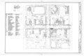 | 14,500 × 9,632 (1.22 MB) | Fæ | GWToolset: Creating mediafile for Fæ. HABS 11 July 2014 (1001:1200) |
Amfani da fayil
Wadannan shafi na amfani wannan fayil:
Amfanin fayil a ko'ina
Wadannan sauran wikis suna amfani da fayil din anan
- Amfani a kan bn.wikipedia.org
- Amfani a kan en.wikipedia.org