Fayil:KanagawaMapCurrent.png
Yanayin wannan rigayi gani: 800 × 500 pixels. Wasu yarjejeniyoyi: 320 × 200 pixels | 640 × 400 pixels | 1,024 × 640 pixels | 1,281 × 801 pixels.
Hoton asali (pikisal 1,281 × 801, girman fayil: 134 KB, irin MIME: image/png)
Taƙaici
| Bayani |
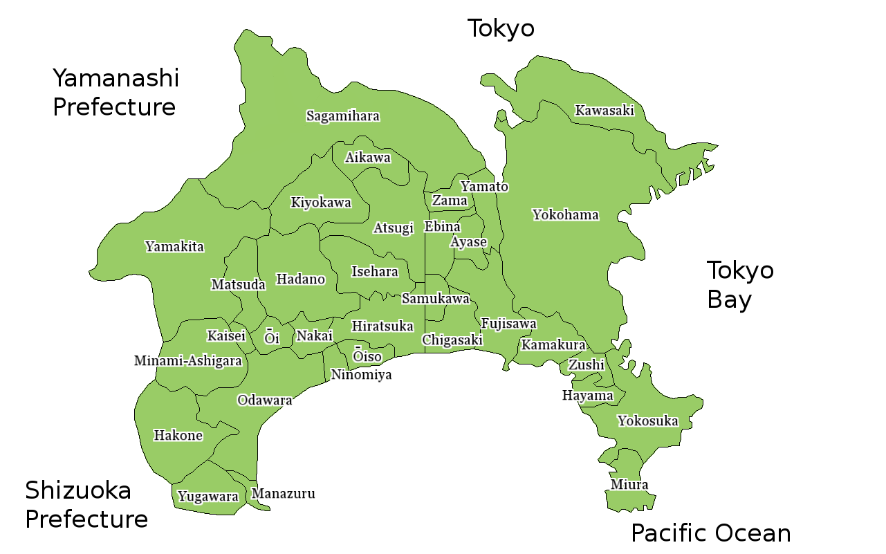
Map of Kanagawa Prefecture, Japan. Thanks to Aoki Shigenobu and [1]. Colors from Image:TokyoMapCurrent.png by User:Fg2. |
| Rana | 18 Yuli 2006 (original upload date) |
| Masomi | No machine-readable source provided. Own work assumed (based on copyright claims). |
| Marubucin | No machine-readable author provided. Akanemoto~commonswiki assumed (based on copyright claims). |
Lasisi
| I, the copyright holder of this work, release this work into the public domain. This applies worldwide. In some countries this may not be legally possible; if so: I grant anyone the right to use this work for any purpose, without any conditions, unless such conditions are required by law. |
Tarihin fayil
Ku latsa rana/lokaci ku ga fayil yadda yake a wannan lokaci
| Rana/Lokaci | Wadar sufa | Kusurwowi | Ma'aikaci | Bahasi | |
|---|---|---|---|---|---|
| na yanzu | 15:26, 25 ga Maris, 2010 | | 1,281 × 801 (134 KB) | MIsogi | update |
| 14:10, 10 ga Yuni, 2007 |  | 1,281 × 801 (40 KB) | Alberth2 | Sagamihara City has merged some towns and villages. | |
| 11:19, 18 ga Yuli, 2006 |  | 1,281 × 801 (38 KB) | Akanemoto~commonswiki | Map of Kanagawa Prefecture, Japan. Thanks to Aoki Shigenobu and [http://aoki2.si.gunma-u.ac.jp/map/map.html]. Colors from Image:TokyoMapCurrent.png by User:Fg2. Category:Maps of Kanagawa prefecture Category:Maps in English |
Amfani da fayil
Babu shafuka da suke amfani da fayil din nan.
Amfanin fayil a ko'ina
Wadannan sauran wikis suna amfani da fayil din anan
- Amfani a kan ast.wikipedia.org
- Amfani a kan az.wikipedia.org
- Amfani a kan be.wikipedia.org
- Amfani a kan ckb.wikipedia.org
- Amfani a kan cs.wikipedia.org
- Amfani a kan es.wikipedia.org
- Amfani a kan eu.wikipedia.org
- Amfani a kan fa.wikipedia.org
- Amfani a kan fi.wikipedia.org
- Amfani a kan lt.wikipedia.org
- Amfani a kan ms.wikipedia.org
- Amfani a kan no.wikipedia.org
- Amfani a kan pam.wikipedia.org
- Amfani a kan pl.wikipedia.org
- Amfani a kan ru.wikipedia.org
- Amfani a kan vi.wikipedia.org
- Amfani a kan www.wikidata.org