File:Hong Kong Night Skyline.jpg

Yanayin wannan rigayi gani: 800 × 343 pixels. Wasu yarjejeniyoyi: 320 × 137 pixels | 640 × 274 pixels | 1,024 × 439 pixels | 1,280 × 548 pixels | 4,670 × 2,000 pixels.
Hoton asali (pikisal 4,670 × 2,000, girman fayil: 8.44 MB, irin MIME: image/jpeg)
Taƙaici
| Bayani |
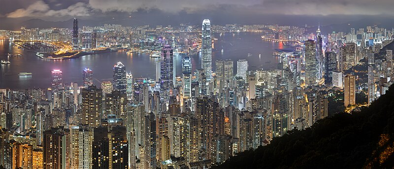
English: A 46 segment × 3 exposure HDR panorama of the Hong Kong night skyline. Taken from Lugard Road at Victoria Peak. Español: Un 46 segmento × 3 exposción HDR. Pánorama de Hong Kong durante la noche. Tomada desde Lugard Road en el Victoria Peak. Français : Vue panoramique de Hong Kong depuis Lugard Road sur Victoria Peak. Image construite en assemblant 138 clichés (46 visées × 3 expositions) réalisés et un objectif 70-200mm f/4L. Italiano: Vista notturna di Hong Kong dal Victoria Peak. Türkçe: Hong Kong şehrinin HDR (A 46 bölüm x 3 pozlama) tekniği kullanılarak Victoria Zirvesi'nden çekilmiş bir gece panoraması. Русский: Панорама Гонконга по уровню ночного горизонта в цветах обычного динамического диапазона, состоящая из 46 сегментов, снятых каждый с тремя значениями экспозиции. Отснята с дороги Лугарда, проходящей по пику Виктория. فارسی : سراسرنمایی از شهر هنگ کنگ. عکسبرداری شده از جاده لوگارد، قله ویکتوریا. |
| Rana | |
| Masomi | Aikin na |
| Marubucin | Base64, retouched by CarolSpears |
| Other versions |
|


| Camera location | | View this and other nearby images on: OpenStreetMap |
|---|
| Camera Model | Canon EOS 400D |
|---|---|
| Lens | Canon EF 70-200mm f/4L USM |
| Notes | Software: Adobe Photoshop CS3, PTgui, DxO Optics, GIMP 2.5, TuFuse
Correction: Noise, Chromatic aberration, Vignetting, Distortion |
| This is a retouched picture, which means that it has been digitally altered from its original version. Modifications: Cloned duplicated moving objects. Modifications made by CarolSpears.
|
|

This image was selected as picture of the day on Wikimedia Commons for 7 September 2008. It was captioned as follows: English: Hong Kong night skyline. Taken from Lugard Road at Victoria Peak. Other languages:
Bosanski: Noćni horizont Hong Konga. Slikano sa puta Lugard na vrhu Victoria. Čeština: Noční panorama centra Hongkongu Dansk: Hong Kongs skyline om natten, fotograferet fra Victoria Peak. Deutsch: Nächtliche Skyline von Hong Kong, VR China von der Lugard Road auf dem Victoria Peak aufgenommen. English: Hong Kong night skyline. Taken from Lugard Road at Victoria Peak. Español: Vista nocturna del distrito central de Hong Kong, desde la Cumbre Victoria. Esperanto: Nokta panoramo de Honkongo. Fotita de la strato Lugard ĉe montopinto Victoria. Français : Vue nocturne de Hong Kong, prise depuis Lugard Road sur le Victoria Peak. Gaeilge: Hong Cong san oíche, pictiúr a tógadh ó Bóthar Lugard ar Victoria Peak. Italiano: Vista notturna di Hong Kong dal Victoria Peak, Cina. Magyar: Hongkong éjszakai fényei, a Victoria-csúcson futó Lugard Road felől Română: Panoramă nocturnă a orașului Hong Kong. Vedere de pe vârful Victoria. Svenska: Hong Kongs skyline på natten, fotograferat från Victoria Peak. Українська: Панорама нічного Гонконгу. 한국어: 홍콩의 야경. 빅토리아 피크의 루가드 로드에서 촬영. 日本語: 香港の夜のスカイライン ビクトリアピークの廬吉道から撮影 中文: 香港夜景,拍摄于太平山卢吉道 |
Lasisi
I, the copyright holder of this work, hereby publish it under the following license:
Wannan fayil ɗin an bada lasisin shi ƙarƙashin Creative Commons Attribution-Share Alike 3.0 Unported lasisi.
- Za ka iya:
- a raba – dan kwafa, yadawa da aika aikin
- dan maimaita – dan daukar aikin
- A karkashin wannan sharuddan
- Jinginarwa – Dole ku bada jinjina da ta dace, samar da linki zuwa lasisin, da kuma bayyana ko kunyi sauyi. Zaku iya haka ta yadda ta dace, amma ba kowace hanya ba wanda zai nuna mai-lasisin yana goyon bayan ku ba ko goyon bayan amfanin da kuke yi ba.
- Yada ahaka – Idan kuka maimaita, sabuntawa, ko kari akan wannan, dole ku bayar da gudunmuwar ku karkashin iri daya ko lasisi data dace kamar na asali.
Tarihin fayil
Ku latsa rana/lokaci ku ga fayil yadda yake a wannan lokaci
| Rana/Lokaci | Wadar sufa | Kusurwowi | Ma'aikaci | Bahasi | |
|---|---|---|---|---|---|
| na yanzu | 14:49, 15 ga Yuni, 2008 | | 4,670 × 2,000 (8.44 MB) | Base64 | {{Information |Description={{en|1=A 46 segment × 3 exposure panoramic view of the Hong Kong night skyline. }} |Source=Own work by uploader |Author=Base64, retouched by CarolSpears |Date=2008-6-15 |Permission=See below |
Amfani da fayil
Wadannan shafi na amfani wannan fayil:
Amfanin fayil a ko'ina
Wadannan sauran wikis suna amfani da fayil din anan
- Amfani a kan af.wikipedia.org
- Amfani a kan ar.wikipedia.org
- Amfani a kan arz.wikipedia.org
- Amfani a kan ast.wikipedia.org
- Amfani a kan awa.wikipedia.org
- Amfani a kan az.wikipedia.org
- Amfani a kan ba.wikipedia.org
- Amfani a kan bg.wikipedia.org
- Amfani a kan bi.wikipedia.org
- Amfani a kan bm.wikipedia.org
- Amfani a kan bn.wikipedia.org
- Amfani a kan bo.wikipedia.org
- Amfani a kan bs.wikipedia.org
- Amfani a kan bxr.wikipedia.org
- Amfani a kan ca.wikipedia.org
- Amfani a kan chy.wikipedia.org
- Amfani a kan crh.wikipedia.org
- Amfani a kan cs.wikipedia.org
- Amfani a kan cv.wikipedia.org
- Amfani a kan cy.wikipedia.org
- Amfani a kan de.wikipedia.org
Duba ƙarin amfanin wannan fayil.