File:Hawaje-NoRedLine.jpg

Hoton asali (pikisal 3,600 × 2,800, girman fayil: 2.81 MB, irin MIME: image/jpeg)
Taƙaici
| Bayani |
Čeština: Satelitní pohled na Havajské ostrovy
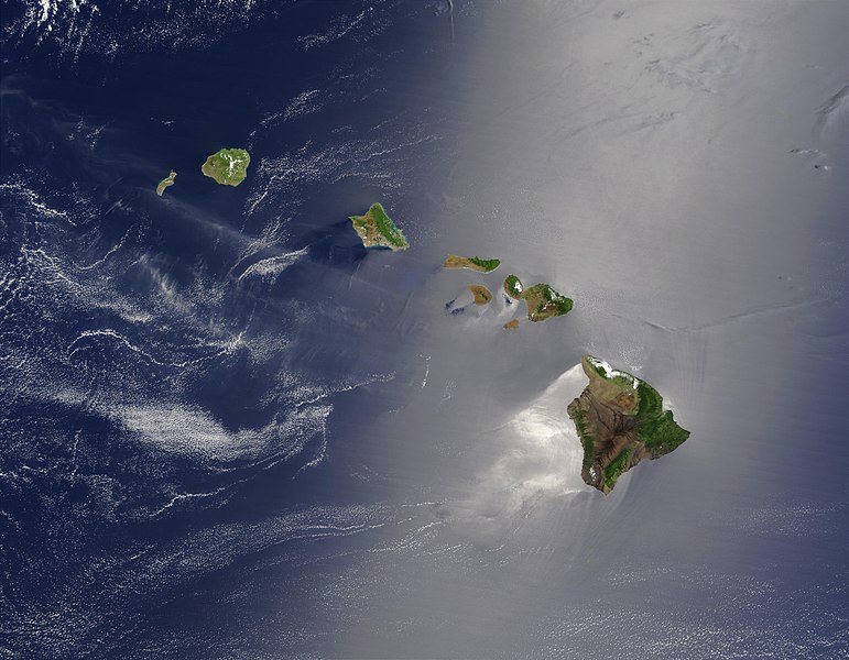
English: Satellite view of Hawaii archipelago (USA) Original description from NASA:
Français : Vue satellite de l'archipel d'Hawaï (États-Unis) |
| Rana | |
| Masomi |
|
| Marubucin | Jacques Descloitres |
| Other versions |
 |
| This is a retouched picture, which means that it has been digitally altered from its original version. Modifications: cloned out and healed little red line on the big island. The original can be viewed here: Hawaje.jpg:
|
Lasisi
| This file is in the public domain in the United States because it was solely created by NASA. NASA copyright policy states that "NASA material is not protected by copyright unless noted". (See Template:PD-USGov, NASA copyright policy page or JPL Image Use Policy.) | ||
 |
Warnings:
|
Original upload log
This file was derived from: Hawaje.jpg
- File:Hawaje.jpg licensed with PD-USGov-NASA
- 2005-10-26T18:19:43Z Palladinus 3600x2800 (1211908 Bytes) Hawaii Islands
Uploaded with derivativeFX
Assessment
|
This image was selected as picture of the day on Wikimedia Commons for 16 June 2011. It was captioned as follows: Other languages:
Čeština: Satelitní pohled na Havajské ostrovy Eesti: Hawaii saared satelliidifotol. Magyar: Hawaii szigetvilágának műholdas képe Português: Texto de cabeçalho. Русский: Спутниковая фотография Гавайских островов 한국어: 하와이 제도의 위성 사진. 日本語: ハワイ諸島の衛星写真 中文: 美国夏威夷的卫星照片 |
Tarihin fayil
Ku latsa rana/lokaci ku ga fayil yadda yake a wannan lokaci
| Rana/Lokaci | Wadar sufa | Kusurwowi | Ma'aikaci | Bahasi | |
|---|---|---|---|---|---|
| na yanzu | 22:24, 1 Satumba 2010 | | 3,600 × 2,800 (2.81 MB) | IdLoveOne~commonswiki | {{RetouchedPicture|cloned out and healed little red line on the big island|editor=IdLoveOne|orig=Hawaje.jpg}} {{self|PD-USGov-NASA}} == {{Original upload log}} == This image is a derivative work of the following images: *File:Hawaje.jpg licensed w |
Amfani da fayil
Wadannan shafi na amfani wannan fayil:
Amfanin fayil a ko'ina
Wadannan sauran wikis suna amfani da fayil din anan
- Amfani a kan ace.wikipedia.org
- Amfani a kan af.wikipedia.org
- Amfani a kan als.wikipedia.org
- Amfani a kan ar.wikipedia.org
- Amfani a kan ary.wikipedia.org
- Amfani a kan arz.wikipedia.org
- Amfani a kan ast.wikipedia.org
- Amfani a kan azb.wikipedia.org
- Amfani a kan az.wikipedia.org
- Amfani a kan ba.wikipedia.org
- Amfani a kan be-tarask.wikipedia.org
- Amfani a kan bh.wikipedia.org
- Amfani a kan bn.wikipedia.org
- Amfani a kan bn.wikibooks.org
- Amfani a kan ca.wikipedia.org
- Amfani a kan ceb.wikipedia.org
- Amfani a kan crh.wikipedia.org
- Amfani a kan cs.wikipedia.org
- Amfani a kan cv.wikipedia.org
- Amfani a kan cy.wikipedia.org
- Amfani a kan dag.wikipedia.org
- Amfani a kan de.wikipedia.org
- Amfani a kan diq.wikipedia.org
- Amfani a kan el.wikipedia.org
- Amfani a kan en.wikipedia.org
Duba ƙarin amfanin wannan fayil.