File:Europe-Jersey.svg

Size of this PNG preview of this SVG file: 713 × 600 pixels. Wasu yarjejeniyoyi: 285 × 240 pixels | 571 × 480 pixels | 913 × 768 pixels | 1,218 × 1,024 pixels | 2,435 × 2,048 pixels | 2,045 × 1,720 pixels.
Hoton asali (Fayil kin SVG, saƙar fikisal 2,045 x 1,720, girman fayil: 7.73 MB)
Taƙaici
| Bayani |
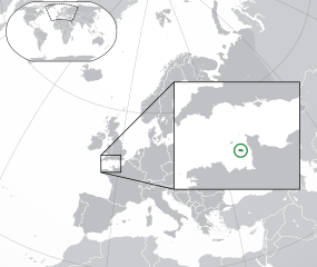
English: The Full Map of Jersey |
||
| Rana | |||
| Masomi |
Own work based on: Europe-Northern Cyprus.svg and Europe-Serbia.svg |
||
| Marubucin | Chipmunkdavis | ||
| Other versions |
Derivative works of this file: |
||
| SVG genesis |
|

Lasisi
Wannan fayil ɗin an bada lasisin shi ƙarƙashin Creative Commons Attribution-Share Alike 3.0 Unported lasisi.
- Za ka iya:
- a raba – dan kwafa, yadawa da aika aikin
- dan maimaita – dan daukar aikin
- A karkashin wannan sharuddan
- Jinginarwa – Dole ku bada jinjina da ta dace, samar da linki zuwa lasisin, da kuma bayyana ko kunyi sauyi. Zaku iya haka ta yadda ta dace, amma ba kowace hanya ba wanda zai nuna mai-lasisin yana goyon bayan ku ba ko goyon bayan amfanin da kuke yi ba.
- Yada ahaka – Idan kuka maimaita, sabuntawa, ko kari akan wannan, dole ku bayar da gudunmuwar ku karkashin iri daya ko lasisi data dace kamar na asali.
Original upload log
This image is a derivative work of the following images:
- Europe-Northern Cyprus.svg licensed with Cc-by-3.0
- 2011-02-20T17:16:12Z Chipmunkdavis 2045x1720 (2331880 Bytes) {{Information |Description={{en|1={{Europe-SVG-en|Northern Cyprus}}}} |Source=*[[:File:Europe-Serbia.svg|]] |Date=2011-02-20 17:14 (UTC) |Author=*[[:File:Europe-Serbia.svg|]]: {{click|image=TheEmirr-Logo.png|link=User:The Emi
- Jersey Map.svg licensed with PD-self
- 2009-04-02T01:46:41Z Ichwan Palongengi 626x433 (208689 Bytes) Remove the flaw...
- 2009-04-02T01:39:59Z Ichwan Palongengi 626x433 (207980 Bytes) {{Information |Description={{en|1=The Full Map of Jersey}} |Source=Own work by uploader |Author=[[User:Ichwan Palongengi|Ichwan Palongengi]] |Date=2009-03-01 |Permission= |other_versions= }} [[Category:Jersey]]
Uploaded with derivativeFX
Tarihin fayil
Ku latsa rana/lokaci ku ga fayil yadda yake a wannan lokaci
| Rana/Lokaci | Wadar sufa | Kusurwowi | Ma'aikaci | Bahasi | |
|---|---|---|---|---|---|
| na yanzu | 01:57, 8 Nuwamba, 2017 | | 2,045 × 1,720 (7.73 MB) | Rob984 | Added circle like the original |
| 00:35, 8 Nuwamba, 2017 |  | 2,045 × 1,720 (7.73 MB) | Rob984 | Modified to try to better locate the island both within the Channel and Europe (so multiple maps aren't needed) | |
| 07:49, 21 ga Faburairu, 2011 |  | 2,045 × 1,720 (2.28 MB) | Chipmunkdavis | {{Information |Description={{en|1={{Europe-SVG-en|Northern Cyprus}}}} {{en|1=The Full Map of Jersey}} |Source=*File:Europe-Northern_Cyprus.svg *File:Jersey_Map.svg |Date=2011-02-21 07:48 (UTC) |Author=*File:Europe-Northern_Cyprus.svg: *[ |
Amfani da fayil
Wadannan shafi na amfani wannan fayil:
Amfanin fayil a ko'ina
Wadannan sauran wikis suna amfani da fayil din anan
- Amfani a kan af.wikipedia.org
- Amfani a kan ang.wikipedia.org
- Amfani a kan ar.wikipedia.org
- Amfani a kan arz.wikipedia.org
- Amfani a kan ast.wikipedia.org
- Amfani a kan azb.wikipedia.org
- Amfani a kan az.wikipedia.org
- Amfani a kan be-tarask.wikipedia.org
- Amfani a kan be.wikipedia.org
- Amfani a kan bh.wikipedia.org
- Amfani a kan bn.wikipedia.org
- Amfani a kan ca.wikipedia.org
- Amfani a kan cdo.wikipedia.org
- Amfani a kan chr.wikipedia.org
- Amfani a kan cs.wikipedia.org
- Amfani a kan da.wikipedia.org
- Amfani a kan diq.wikipedia.org
- Amfani a kan en.wikipedia.org
- Amfani a kan en.wikivoyage.org
- Amfani a kan es.wikipedia.org
- Amfani a kan fa.wikipedia.org
- Amfani a kan fi.wikipedia.org
- Amfani a kan fr.wikipedia.org
- Amfani a kan ga.wikipedia.org
- Amfani a kan gl.wikipedia.org
- Amfani a kan hak.wikipedia.org
- Amfani a kan he.wikipedia.org
- Amfani a kan he.wikivoyage.org
- Amfani a kan hr.wikipedia.org
- Amfani a kan hy.wikipedia.org
- Amfani a kan ia.wikipedia.org
- Amfani a kan incubator.wikimedia.org
- Amfani a kan is.wikipedia.org
- Amfani a kan it.wikipedia.org
Duba ƙarin amfanin wannan fayil.