File:Eritrea - Location Map (2013) - ERI - UNOCHA.svg

Hoton asali (Fayil kin SVG, saƙar fikisal 254 x 254, girman fayil: 262 KB)
_-_ERI_-_UNOCHA.svg)
Taƙaici
| Bayani |
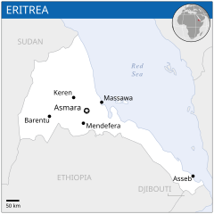
English: Locator map of Eritrea. |
| Rana | |
| Masomi |
English: Eritrea Locator Map (ReliefWeb), ESRI, UNCS, Natural Earth |
| Marubucin | |
| SVG genesis |
Lasisi
- Za ka iya:
- a raba – dan kwafa, yadawa da aika aikin
- dan maimaita – dan daukar aikin
- A karkashin wannan sharuddan
- Jinginarwa – Dole ku bada jinjina da ta dace, samar da linki zuwa lasisin, da kuma bayyana ko kunyi sauyi. Zaku iya haka ta yadda ta dace, amma ba kowace hanya ba wanda zai nuna mai-lasisin yana goyon bayan ku ba ko goyon bayan amfanin da kuke yi ba.
 This map is part of a collection of 216 free country maps, created by the UN Office for the Coordination of Humanitarian Affairs (OCHA), to be used in print, web or broadcast products.
The ReliefWeb Location Maps released here are maps that highlight a country, its capital, major populated places and the surrounding regions. Attribution Requirements
Using the map without modifications: ensure that the sources and the disclaimer are below the map. Credit as follows: "Credit: OCHA". For use with alteration: remove the OCHA logo and disclaimer following any modification to the map, but keep the data sources as mentioned below the map. Credit the modified map as follows: "Based on OCHA map". You are responsible for the content of your map. We are keen to receive your feedback and hear how you used OCHA's maps. We would be grateful if you would notify us by e-mail and share your work with us. UN Disclaimer
The designations employed and the presentation of material of this map do not imply the expression of any opinion whatsoever on the part of the Secretariat of the United Nations concerning the legal status of any country, territory, city or area or of its authorities or concerning the delimitation of its frontiers or boundaries. |
Tarihin fayil
Ku latsa rana/lokaci ku ga fayil yadda yake a wannan lokaci
| Rana/Lokaci | Wadar sufa | Kusurwowi | Ma'aikaci | Bahasi | |
|---|---|---|---|---|---|
| na yanzu | 02:52, 29 Disamba 2022 | | 254 × 254 (262 KB) | Wikijahnn | File uploaded using svgtranslate tool (https://svgtranslate.toolforge.org/). Added translation for ca. |
| 23:54, 18 Nuwamba, 2014 |  | 254 × 254 (263 KB) | Pharos | try without logo for now | |
| 03:12, 18 Nuwamba, 2014 |  | 254 × 254 (302 KB) | Pharos | try without logo for now | |
| 00:28, 21 ga Afirilu, 2014 |  | 254 × 254 (302 KB) | UN OCHA maps bot | == {{int:filedesc}} == {{Information |description={{en|1=Locator map of Eritrea.}} |date=2013 |source={{en|1=[http://reliefweb.int/map/eritrea/eritrea-location-map-2013 Eritrea Locator Map (ReliefWeb)]}} |author={{en|1=[[w:en:United Na... |
Amfani da fayil
Wadannan shafi na amfani wannan fayil:
Amfanin fayil a ko'ina
Wadannan sauran wikis suna amfani da fayil din anan
- Amfani a kan bh.wikipedia.org
- Amfani a kan ca.wikipedia.org
- Amfani a kan ckb.wikipedia.org
- Amfani a kan en.wikipedia.org
- Amfani a kan es.wikipedia.org
- Amfani a kan id.wikipedia.org
- Amfani a kan ilo.wikipedia.org
- Amfani a kan ja.wikipedia.org
- Amfani a kan lb.wikipedia.org
- Amfani a kan lfn.wikipedia.org
- Amfani a kan lo.wikipedia.org
- Amfani a kan mdf.wikipedia.org
- Amfani a kan mg.wikipedia.org
- Amfani a kan mt.wikipedia.org
- Amfani a kan pl.wikipedia.org
- Amfani a kan rm.wikipedia.org
- Amfani a kan ro.wikipedia.org
- Amfani a kan sco.wikipedia.org
- Amfani a kan sd.wikipedia.org
- Amfani a kan so.wikipedia.org
- Amfani a kan th.wikipedia.org
_-_ERI_-_UNOCHA.svg)