Fayil:ECEF ENU Longitude Latitude relationships.svg

Size of this PNG preview of this SVG file: 520 × 500 pixels. Wasu yarjejeniyoyi: 250 × 240 pixels | 499 × 480 pixels | 799 × 768 pixels | 1,065 × 1,024 pixels | 2,130 × 2,048 pixels.
Hoton asali (Fayil kin SVG, saƙar fikisal 520 x 500, girman fayil: 26 KB)
| Bayani | |||
| Rana | |||
| Masomi | Based on en:File:EarthTangentialPlane.png by en:User:Raffyl99 (public domain) | ||
| Marubucin | Mike1024 | ||
| Izini (Sake amfani da wannan fayil) |
|
||
| Other versions | en:File:EarthTangentialPlane.png |
Tarihin fayil
Ku latsa rana/lokaci ku ga fayil yadda yake a wannan lokaci
| Rana/Lokaci | Wadar sufa | Kusurwowi | Ma'aikaci | Bahasi | |
|---|---|---|---|---|---|
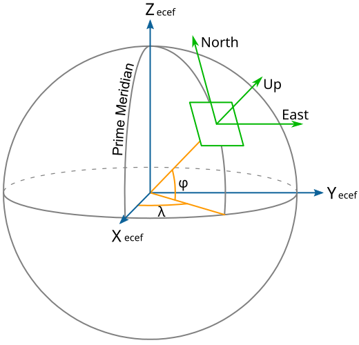
| na yanzu | 22:49, 18 ga Faburairu, 2010 | | 520 × 500 (26 KB) | Mike1024 | {{Information |Description={{en|A diagram showing ECEF, ENU, Longitude (λ) and Latitude (φ) coordinates and the relationship between them.}} |Source=Based on [[:en:File:EarthTangenti |
Amfani da fayil
Wadannan shafi na amfani wannan fayil:
Amfanin fayil a ko'ina
Wadannan sauran wikis suna amfani da fayil din anan
- Amfani a kan cs.wikipedia.org
- Amfani a kan en.wikipedia.org
- Amfani a kan he.wikipedia.org
- Amfani a kan hi.wikipedia.org
- Amfani a kan ru.wikipedia.org
- Amfani a kan sh.wikipedia.org
- Amfani a kan tr.wikipedia.org
- Amfani a kan uz.wikipedia.org