File:Chacaltaya Pano MC.jpg

Yanayin wannan rigayi gani: 800 × 258 pixels. Wasu yarjejeniyoyi: 320 × 103 pixels | 640 × 207 pixels | 1,024 × 330 pixels | 1,280 × 413 pixels | 2,560 × 826 pixels | 10,000 × 3,227 pixels.
Hoton asali (pikisal 10,000 × 3,227, girman fayil: 12.42 MB, irin MIME: image/jpeg)
|

Taƙaici
| Bayani |
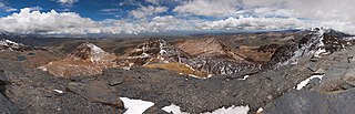
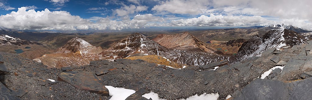
English: A panoramic view from the top of Chacaltaya (5421m). In the background you can see the cities of La Paz and El Alto (distance about 15km), as well as Lake Titicaca (distance about 50km). Panorama stitched from 16 portrait format images. The camera was rotated using a Nodal Ninja [1] nodal point adapter which was mounted on a tripod. All photos were taken with the same exposure settings in RAW format and developed with exactly the same settings in a RAW converter. For stitching PTGUI [2] was used.
Deutsch: Panorama vom Gipfel des Chacaltaya (5421 m). Im Hintergrund sieht man die Städte La Paz und El Alto (Entfernung etwa 15 km) sowie den Titicacasee (Entfernung etwa 50 km). Panorama zusammengesetzt aus 16 Hochformatbildern. Die Kamera wurde mit Hilfe eines Nodal Ninja [3] Nodalpunktadapters (der auf einem Stativ befestigt war) rotiert. Alle Fotos wurden mit denselben Belichtungseinstellungen im RAW-Format aufgezeichnet und mit denselben Einstellungen in einem RAW-Konverter entwickelt. Zum Zusammenfügen wurde PTGUI [4] verwendet.
Français : Vue panoramique prise du sommet du Chacaltaya (5421m). A l'arrière-plan, on peut discerner les villes de La Paz et El Alto (distance d'environ 15km), aussi bien que le lac Titicaca (distance d'environ 50km). Panorama ubtenu par la fusion de 16 images au format portrait. L'appareil photo a été mis en rotation avec un adaptateur Nodal Ninja [5] monté sur trépied. Toutes les photos ont été prises avec la même exposition en format RAW et développées avec les mêmes réglages. La fusion a été réalisée avec PTGUI [6]. |
| Rana | |
| Masomi | Aikin na |
| Marubucin | Christian Mehlführer, User:Chmehl |
| Camera location | | View this and other nearby images on: OpenStreetMap |
|---|
Lasisi
I, the copyright holder of this work, hereby publish it under the following license:
This file is licensed under the Creative Commons Attribution 3.0 Unported license.
- Za ka iya:
- a raba – dan kwafa, yadawa da aika aikin
- dan maimaita – dan daukar aikin
- A karkashin wannan sharuddan
- Jinginarwa – Dole ku bada jinjina da ta dace, samar da linki zuwa lasisin, da kuma bayyana ko kunyi sauyi. Zaku iya haka ta yadda ta dace, amma ba kowace hanya ba wanda zai nuna mai-lasisin yana goyon bayan ku ba ko goyon bayan amfanin da kuke yi ba.
Tarihin fayil
Ku latsa rana/lokaci ku ga fayil yadda yake a wannan lokaci
| Rana/Lokaci | Wadar sufa | Kusurwowi | Ma'aikaci | Bahasi | |
|---|---|---|---|---|---|
| na yanzu | 20:57, 15 ga Afirilu, 2009 | 10,000 × 3,227 (12.42 MB) | Chmehl | straightened panorama and corrected tilt | |
| 19:37, 15 ga Afirilu, 2009 | 9,000 × 2,931 (10.5 MB) | Chmehl | straightened panorama and corrected tilt | ||
| 15:28, 13 ga Afirilu, 2009 | 9,000 × 2,838 (10.98 MB) | Chmehl | {{Information |Description={{en|1=A panoramic view from the top of Chacaltaya (5421m). In the background you can see the cities of La Paz and El Alto (distance about 15km), as well as [[:en:Lake_Titicaca|L |
Amfani da fayil
Wadannan shafi na amfani wannan fayil:
Amfanin fayil a ko'ina
Wadannan sauran wikis suna amfani da fayil din anan
- Amfani a kan es.wikipedia.org
- Amfani a kan fa.wikipedia.org
- Amfani a kan fr.wikipedia.org
- Amfani a kan id.wikipedia.org
- Amfani a kan krc.wikipedia.org
- Amfani a kan pl.wikipedia.org
- Amfani a kan tr.wikipedia.org
- Vikipedi:Seçkin resimler/Mekânlar/Panorama
- Chacaltaya
- Vikipedi:Seçkin resim adayları/Chacaltaya Pano MC.jpg
- Vikipedi:Seçkin resim adayları/Arşiv/Şubat 2010
- Vikipedi:Günün seçkin resmi/Ağustos 2011
- Şablon:GSR/2011-08-03
- Vikipedi:Seçkin resimler/Ana sayfaya çıkmış resimler/2011 listesi
- Vikipedi:Seçkin resimler/Ana sayfaya çıkmış resimler/2014 listesi
- Vikipedi:Günün seçkin resmi/Aralık 2014
- Şablon:GSR/2014-12-05
- Şablon:GSR/2017-05-11
- Vikipedi:Günün seçkin resmi/Mayıs 2017
- Amfani a kan vi.wikipedia.org