File:CarthageMap.png
Babu wata babbar saƙa.
CarthageMap.png (pikisal 770 × 447, girman fayil: 106 KB, irin MIME: image/png)
Taƙaici
| Bayani |
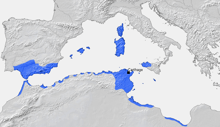
Location of Carthage and Carthaginian sphere of influence prior to the First Punic War (264 BC) Source: Self-made, based on Putzger Atlas und Chronik zur Weltgeschichte, Berlin, 2002 Template: [1] Author: BishkekRocks |
||
| Rana | 18 Maris 2006 (original upload date) | ||
| Masomi | No machine-readable source provided. Own work assumed (based on copyright claims). | ||
| Marubucin | No machine-readable author provided. BishkekRocks assumed (based on copyright claims). | ||
| Other versions |
|

Lasisi
| I, the copyright holder of this work, release this work into the public domain. This applies worldwide. In some countries this may not be legally possible; if so: I grant anyone the right to use this work for any purpose, without any conditions, unless such conditions are required by law. |
Tarihin fayil
Ku latsa rana/lokaci ku ga fayil yadda yake a wannan lokaci
| Rana/Lokaci | Wadar sufa | Kusurwowi | Ma'aikaci | Bahasi | |
|---|---|---|---|---|---|
| na yanzu | 19:50, 6 ga Afirilu, 2023 | | 770 × 447 (106 KB) | Titanjs | Reverted to version as of 15:31, 18 March 2006 (UTC) |
| 14:16, 23 ga Maris, 2016 |  | 770 × 447 (288 KB) | Michczu | drobna poprawka | |
| 16:52, 19 Satumba 2014 |  | 770 × 447 (128 KB) | Daygum | True areas occupied by chartaginians | |
| 15:31, 18 ga Maris, 2006 |  | 770 × 447 (106 KB) | BishkekRocks | Location of Carthage and Carthaginian influence sphere before the First Punic War (264 BC) Source: Self-made, based on Putzger Atlas und Chronik zur Weltgeschichte, Berlin, 2002 Template: [http://www.demis.nl/wms/mapclip.htm] Author: ~~~ [[Category:Ca |
Amfani da fayil
Wadannan shafi na amfani wannan fayil:
Amfanin fayil a ko'ina
Wadannan sauran wikis suna amfani da fayil din anan
- Amfani a kan ar.wikipedia.org
- Amfani a kan ast.wikipedia.org
- Amfani a kan azb.wikipedia.org
- Amfani a kan az.wikipedia.org
- Amfani a kan ba.wikipedia.org
- Amfani a kan be-tarask.wikipedia.org
- Amfani a kan bg.wikipedia.org
- Amfani a kan bm.wikipedia.org
- Amfani a kan br.wikipedia.org
- Amfani a kan bs.wikipedia.org
- Amfani a kan ca.wikipedia.org
- Amfani a kan cdo.wikipedia.org
- Amfani a kan cs.wikipedia.org
- Amfani a kan de.wikipedia.org
- Amfani a kan el.wikipedia.org
- Amfani a kan en.wikipedia.org
- Amfani a kan eo.wikipedia.org
- Amfani a kan es.wikipedia.org
Duba ƙarin amfanin wannan fayil.