Fayil:Arctic circle.svg

Size of this PNG preview of this SVG file: 478 × 599 pixels. Wasu yarjejeniyoyi: 191 × 240 pixels | 383 × 480 pixels | 613 × 768 pixels | 817 × 1,024 pixels | 1,634 × 2,048 pixels | 505 × 633 pixels.
Hoton asali (Fayil kin SVG, saƙar fikisal 505 x 633, girman fayil: 1.63 MB)
Taƙaici
| Bayani |
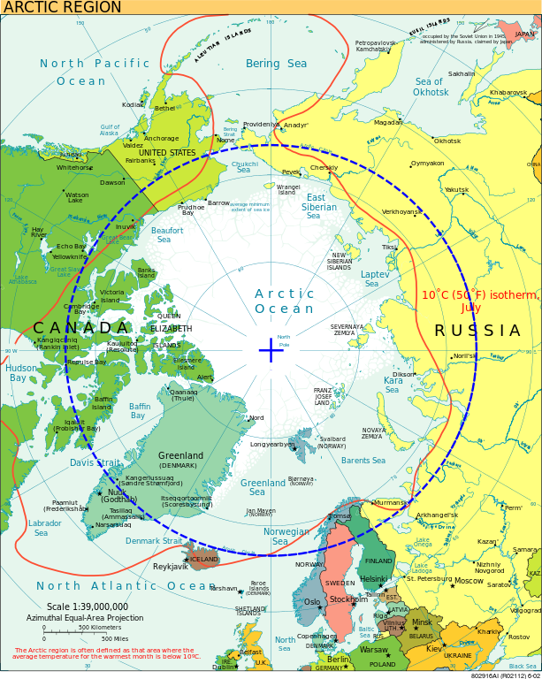
English: Map of the Arctic with the Arctic Circle in blue.
Français : Carte de l'Arctique avec le cercle Arctique en bleu. |
| Masomi | File:Arctic.svg, from the CIA World Fact Book |
| Marubucin | CIA World Fact Book |
| Other versions |
[]
|


.svg)


Lasisi
This image is in the public domain because it contains materials that originally came from the United States Central Intelligence Agency's World Factbook.
|
 |
Other versions
-
 македонски
| Annotations | This image is annotated: View the annotations at Commons |
Tarihin fayil
Ku latsa rana/lokaci ku ga fayil yadda yake a wannan lokaci
| Rana/Lokaci | Wadar sufa | Kusurwowi | Ma'aikaci | Bahasi | |
|---|---|---|---|---|---|
| na yanzu | 18:56, 25 Satumba 2009 | | 505 × 633 (1.63 MB) | Thesevenseas | {{Information |Description={{en|1=Map of The Arctic with The Arctic Circle standing out.}} |Source=Arctic.svg |Author=~~~ |Date=2009-09-25 |Permission= |other_versions= }} |
Amfani da fayil
Babu shafuka da suke amfani da fayil din nan.
Amfanin fayil a ko'ina
Wadannan sauran wikis suna amfani da fayil din anan
- Amfani a kan af.wikipedia.org
- Amfani a kan am.wikipedia.org
- Amfani a kan ar.wikipedia.org
- Amfani a kan ast.wikipedia.org
- Amfani a kan az.wikipedia.org
- Amfani a kan ba.wikipedia.org
- Amfani a kan bcl.wikipedia.org
- Amfani a kan bjn.wikipedia.org
- Amfani a kan bn.wikipedia.org
- Amfani a kan bs.wikipedia.org
- Amfani a kan ca.wikipedia.org
- Amfani a kan cs.wikipedia.org
- Amfani a kan cy.wikipedia.org
- Amfani a kan da.wikipedia.org
- Amfani a kan de.wikipedia.org
- Amfani a kan en.wikipedia.org
- Amfani a kan en.wiktionary.org
- Amfani a kan eo.wikipedia.org
- Amfani a kan es.wikipedia.org
- Amfani a kan es.wikibooks.org
- Amfani a kan et.wikipedia.org
- Amfani a kan eu.wikipedia.org
- Amfani a kan frr.wikipedia.org
- Amfani a kan fr.wikipedia.org
- Amfani a kan ga.wikipedia.org
- Amfani a kan he.wikipedia.org
- Amfani a kan he.wiktionary.org
- Amfani a kan hi.wikipedia.org
- Amfani a kan hr.wikipedia.org
Duba ƙarin amfanin wannan fayil.