Fayil:Abbasid Caliphate 891-892.png

Yanayin wannan rigayi gani: 800 × 382 pixels. Wasu yarjejeniyoyi: 320 × 153 pixels | 640 × 306 pixels | 1,024 × 490 pixels | 1,280 × 612 pixels | 3,054 × 1,460 pixels.
Hoton asali (pikisal 3,054 × 1,460, girman fayil: 1.44 MB, irin MIME: image/png)
Taƙaici
| Bayani |
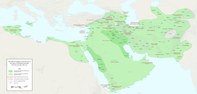
English: Map of the Abbasid Caliphate at the end of the reign of al-Mu'tamid in 891-892. Dark green denotes provinces under the effective control of the central government; light green denotes provinces under the control of autonomous governors or rebels.
The core Abbasid territories include Shahrazur, Darabadh, al-Samaghan, Hulwan, Masabadhan, Mihrijanqadhaq, the Euphrates districts, and Qarqisiyya (al-Tabari v. 37, p. 98; Bianquis p. 96). Map originally created as an .SVG file in Inkscape and converted to .PNG for size reasons. Background topography taken from DEMIS Mapserver, which are public domain. Works Cited:
|
| Rana | |
| Masomi | Aikin na |
| Marubucin | Ro4444 |
| Other versions |
 |
Lasisi
I, the copyright holder of this work, hereby publish it under the following license:
This file is licensed under the Creative Commons Attribution-Share Alike 4.0 International license.
- Za ka iya:
- a raba – dan kwafa, yadawa da aika aikin
- dan maimaita – dan daukar aikin
- A karkashin wannan sharuddan
- Jinginarwa – Dole ku bada jinjina da ta dace, samar da linki zuwa lasisin, da kuma bayyana ko kunyi sauyi. Zaku iya haka ta yadda ta dace, amma ba kowace hanya ba wanda zai nuna mai-lasisin yana goyon bayan ku ba ko goyon bayan amfanin da kuke yi ba.
- Yada ahaka – Idan kuka maimaita, sabuntawa, ko kari akan wannan, dole ku bayar da gudunmuwar ku karkashin iri daya ko lasisi data dace kamar na asali.
Tarihin fayil
Ku latsa rana/lokaci ku ga fayil yadda yake a wannan lokaci
| Rana/Lokaci | Wadar sufa | Kusurwowi | Ma'aikaci | Bahasi | |
|---|---|---|---|---|---|
| na yanzu | 23:18, 3 Disamba 2017 | | 3,054 × 1,460 (1.44 MB) | Ro4444 | Further color corrections |
| 22:50, 3 Disamba 2017 |  | 3,054 × 1,460 (1.44 MB) | Ro4444 | Color correction | |
| 21:11, 3 Disamba 2017 |  | 3,054 × 1,460 (1.44 MB) | Ro4444 | User created page with UploadWizard |
Amfani da fayil
Babu shafuka da suke amfani da fayil din nan.
Amfanin fayil a ko'ina
Wadannan sauran wikis suna amfani da fayil din anan
- Amfani a kan ar.wikipedia.org
- Amfani a kan de.wikiversity.org
- Amfani a kan en.wikipedia.org
- Amfani a kan en.wikibooks.org
- Amfani a kan et.wikipedia.org
- Amfani a kan fa.wikipedia.org
- Amfani a kan hy.wikipedia.org
- Amfani a kan id.wikipedia.org
- Amfani a kan ja.wikipedia.org
- Amfani a kan no.wikipedia.org
- Amfani a kan pt.wikipedia.org
- Amfani a kan sco.wikipedia.org
- Amfani a kan uk.wikipedia.org
- Amfani a kan uz.wikipedia.org
- Amfani a kan zh.wikipedia.org