File:ARG-2016-Aerial-Tierra del Fuego (Ushuaia)–Valle Carbajal 01.jpg

Yanayin wannan rigayi gani: 800 × 534 pixels. Wasu yarjejeniyoyi: 320 × 214 pixels | 640 × 428 pixels | 1,024 × 684 pixels | 1,280 × 855 pixels | 2,560 × 1,710 pixels | 6,335 × 4,232 pixels.
Hoton asali (pikisal 6,335 × 4,232, girman fayil: 19.85 MB, irin MIME: image/jpeg)
|

%E2%80%93Valle_Carbajal_01.jpg)
%E2%80%93Valle_Carbajal_01.jpg)
%E2%80%93Valle_Carbajal_01.jpg)
%E2%80%93Valle_Carbajal_01.jpg)
Taƙaici
| Bayani |
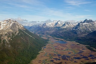
English: Aerial view of Valle Carbajal (terminus) in the Southern Andes, Tierra del Fuego Province, Argentina (Fuegian Andes within a 12 miles radius of Ushuaia) |
| Rana | |
| Masomi | Aikin na |
| Marubucin | Godot13 |
| Other versions | |
| Jinginarwa (required by the license) | Andrew Shiva / Wikipedia / |
| Camera location | | View this and other nearby images on: OpenStreetMap |
|---|
%E2%80%93Valle_Carbajal_01.jpg¶ms=-54.733952_N_-068.184233_E_globe:Earth_type:camera_heading:315.00&language=ha)
Lasisi
I, the copyright holder of this work, hereby publish it under the following license:
This file is licensed under the Creative Commons Attribution-Share Alike 4.0 International license.
- Za ka iya:
- a raba – dan kwafa, yadawa da aika aikin
- dan maimaita – dan daukar aikin
- A karkashin wannan sharuddan
- Jinginarwa – Dole ku bada jinjina da ta dace, samar da linki zuwa lasisin, da kuma bayyana ko kunyi sauyi. Zaku iya haka ta yadda ta dace, amma ba kowace hanya ba wanda zai nuna mai-lasisin yana goyon bayan ku ba ko goyon bayan amfanin da kuke yi ba.
- Yada ahaka – Idan kuka maimaita, sabuntawa, ko kari akan wannan, dole ku bayar da gudunmuwar ku karkashin iri daya ko lasisi data dace kamar na asali.

|
The copyright holder of this file, Andrew Shiva, allows anyone to use it for any purpose, provided that the copyright holder is properly attributed. Redistribution, derivative work, commercial use, and all other use is permitted. |
Jinginarwa:
Use or reproduction of this image outside of Wikipedia must give the original photographer (Andrew Shiva) credit. Although not required, it would be appreciated if a message was left here indicating where this image was being used.
|
Tarihin fayil
Ku latsa rana/lokaci ku ga fayil yadda yake a wannan lokaci
| Rana/Lokaci | Wadar sufa | Kusurwowi | Ma'aikaci | Bahasi | |
|---|---|---|---|---|---|
| na yanzu | 11:34, 22 ga Augusta, 2020 | | 6,335 × 4,232 (19.85 MB) | Fährtenleser | Optimizing contrasts, lights, balances |
| 20:07, 7 ga Faburairu, 2016 |  | 6,335 × 4,232 (17.22 MB) | Godot13 | User created page with UploadWizard |
Amfani da fayil
Wadannan shafi na amfani wannan fayil:
Amfanin fayil a ko'ina
Wadannan sauran wikis suna amfani da fayil din anan
- Amfani a kan ar.wikipedia.org
- Amfani a kan ay.wikipedia.org
- Amfani a kan ceb.wikipedia.org
- Amfani a kan cy.wikipedia.org
- Amfani a kan de.wikipedia.org
- Amfani a kan en.wikipedia.org
- Andes
- Bog
- Wikipedia:WikiProject Argentina
- Wikipedia:Featured pictures/Places/Landscapes
- Wikipedia:WikiProject Argentina/Recognized content
- Wikipedia:WikiProject Geology/Recognized content
- Peatland
- User talk:Godot13/Archive 4
- User:Godot13/Featured Pictures/Photographs
- Wikipedia:WikiProject Geology/Automated list of recognized content
- Wikipedia:Featured pictures thumbs/59
- Wikipedia:Featured picture candidates/February-2016
- Wikipedia:Recent additions/2016/February
- User:Godot13/Antarctica 2016
- Carbajal Valley
- Talk:Carbajal Valley
- Template:Did you know nominations/Carbajal Valley
- Wikipedia:Featured picture candidates/Carbajal Valley, Fuegian Andes (aerial)
- Wikipedia:Wikipedia Signpost/2016-02-24/Featured content
- Portal:Wetlands
- Portal:Wetlands/Did you know
- Wikipedia:Wikipedia Signpost/Single/2016-02-24
- Portal:Wetlands/Did you know/23
- User:Godot13/photographs/2016/Antarctica
- User:Amakuru/POTD 3
- Wikipedia:Picture of the day/January 2019
- Portal:Andes
- Template:POTD/2019-01-12
- Wikipedia:Main Page history/2019 January 12
- User:Gazamp/Safekeeping
- Wikipedia:Did you know/Statistics/Monthly DYK pageview leaders/2016/February
- Amfani a kan es.wikipedia.org
- Amfani a kan fa.wikipedia.org
- Amfani a kan fr.wikipedia.org
- Amfani a kan fy.wikipedia.org
- Amfani a kan gl.wikipedia.org
%E2%80%93Valle_Carbajal_01.jpg)
%E2%80%93Valle_Carbajal_01.jpg)
Duba ƙarin amfanin wannan fayil.
%E2%80%93Valle_Carbajal_01.jpg)
–Valle_Carbajal_01.jpg)