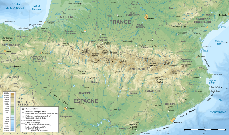
Hoton asali (Fayil kin SVG, saƙar fikisal 3,200 x 1,900, girman fayil: 6.3 MB)

Wannan hoto yazo daga Wikimedia Commons kuma za'a iya amfani dashi a wasu projects. Anan kasa an nuna asalin bayanin shi

Pour agrandir l'image

Detailed map of large dimension. For a better viewing, click on the link of the image above.
Carte détaillée de grande dimension. Pour une visualisation optimale, cliquer sur le lien de l'image ci-dessus.

Taƙaici

Description
English: Topographic map in French of the Pyrenees mountains.
Note: The shaded relief is a raster image embedded in the SVG file.
Français : Carte topographique des Pyrénées en francais.
Note : Le relief ombré est une image bitmap embarquée dans le fichier SVG.
Português: Mapa topográfico (em Francês) dos Pirenéus.
Español: Mapa topográfico (en francés) de los Pirineos.

UTM projection; WGS84 datum; shaded relief (composite image of N-W, W and N lightning positions);

  • The approximate horizontal accuracy of topographic data and shore/lakes limits is 1,125 m (per pixel). This map shouldn't be printed over a 1:1 ratio (27.09 x 16.09cm), which corresponds to a scale of 1:2,010,221.
  • Approximate scale of the bathymetry: 1:7,708,000 (precision: 1,927 m)
SVG genesis
InfoField
 
The source code of this SVG is invalid due to 2 errors.
 
This W3C-invalid map was created with QGIS.
 
 This map uses embedded text that can be easily translated using a text editor.
 
  This SVG map uses embedded raster graphics to show its topographic structures.
Rana May 2007 (modified September 2008)
Masomi

Own work;

Maƙirƙiri
Eric Gaba (Sting - fr:Sting)
Izini
(Sake amfani da wannan fayil)
Attribution and Share-Alike required
Georeferencing Georeference the map in Wikimaps Warper If inappropriate please set warp_status = skip to hide.
Other versions

[gyarawa]


Assessment

Hoto of the year
Hoto of the year
Featured Hoto

Wikimedia Commons

This file was a candidate in Picture of the Year 2007.
This is a featured picture on Wikimedia Commons (Featured pictures) and is considered one of the finest images. See its nomination here.

If you have an image of similar quality that can be published under a suitable copyright license, be sure to upload it, tag it, and nominate it.

Lasisi

I, the copyright holder of this work, hereby publish it under the following licenses:
GNU head An bada damar a kofa, a yaɗa/ko sauya wannan kundi ƙarƙashin Lasisin GNU ta kyauta, Fitarwa na 1.2 ko duk wani fitarwa da zai biyo baya daga Gidauniyar Samar da Software ta Kyauta; ba tare da sauyin sashe ba, babu Rubutun Fuskar gaban shafi, kuma babu Rubutun bayan shafi. Kofi na lasisin na nan an sanya sa aciki ƙarƙashin sashen GNU Free Documentation License.
w:en:Creative Commons
Jinginarwa Yada ahaka
Wannan fayil ɗin an bada lasisin shi ƙarƙashin Creative Commons Attribution-Share Alike 3.0 Unported lasisi.
Za ka iya:
  • a raba – dan kwafa, yadawa da aika aikin
  • dan maimaita – dan daukar aikin
A karkashin wannan sharuddan
  • Jinginarwa – Dole ku bada jinjina da ta dace, samar da linki zuwa lasisin, da kuma bayyana ko kunyi sauyi. Zaku iya haka ta yadda ta dace, amma ba kowace hanya ba wanda zai nuna mai-lasisin yana goyon bayan ku ba ko goyon bayan amfanin da kuke yi ba.
  • Yada ahaka – Idan kuka maimaita, sabuntawa, ko kari akan wannan, dole ku bayar da gudunmuwar ku karkashin iri daya ko lasisi data dace kamar na asali.
This licensing tag was added to this file as part of the GFDL licensing update.
w:en:Creative Commons
Jinginarwa Yada ahaka
This file is licensed under the Creative Commons Attribution-Share Alike 2.5 Generic, 2.0 Generic and 1.0 Generic license.
Za ka iya:
  • a raba – dan kwafa, yadawa da aika aikin
  • dan maimaita – dan daukar aikin
A karkashin wannan sharuddan
  • Jinginarwa – Dole ku bada jinjina da ta dace, samar da linki zuwa lasisin, da kuma bayyana ko kunyi sauyi. Zaku iya haka ta yadda ta dace, amma ba kowace hanya ba wanda zai nuna mai-lasisin yana goyon bayan ku ba ko goyon bayan amfanin da kuke yi ba.
  • Yada ahaka – Idan kuka maimaita, sabuntawa, ko kari akan wannan, dole ku bayar da gudunmuwar ku karkashin iri daya ko lasisi data dace kamar na asali.
Ku na iya zaɓan lasisin da kuke so.

Take

Add a one-line explanation of what this file represents

Abubuwan da aka nuna a cikin wannan fayil

depicts Turanci

copyrighted Turanci

media type Turanci

image/svg+xml

data size Turanci

6,610,680 byte

height Turanci

1,900 pixel

width Turanci

3,200 pixel

checksum Turanci

0d210d72fd90913ce966fc168d3399dc7068a932

Tarihin fayil

Ku latsa rana/lokaci ku ga fayil yadda yake a wannan lokaci

Rana/LokaciWadar sufaKusurwowiMa'aikaciBahasi
na yanzu00:05, 14 Disamba 2012Wadar sufa ta zubin 00:05, 14 Disamba 20123,200 × 1,900 (6.3 MB)Benhuses Helvetica over Arial when available.
15:49, 23 Satumba 2008Wadar sufa ta zubin 15:49, 23 Satumba 20083,200 × 1,900 (6.3 MB)StingUsing ETOPO1 data for bathymetry; new standard colors
00:25, 2 ga Yuli, 2007Wadar sufa ta zubin 00:25, 2 ga Yuli, 20073,200 × 1,900 (5.9 MB)Sting+ projection info in key ; + major cities areas ; some corrections in the rivers
20:30, 25 ga Yuni, 2007Wadar sufa ta zubin 20:30, 25 ga Yuni, 20073,200 × 1,900 (5.88 MB)Sting+ key for borders
21:18, 31 Mayu 2007Wadar sufa ta zubin 21:18, 31 Mayu 20073,200 × 1,900 (5.88 MB)StingSome corrections
18:23, 30 Mayu 2007Wadar sufa ta zubin 18:23, 30 Mayu 20073,200 × 1,900 (5.88 MB)Sting{{Information |Description=Topographic map in French of the Pyrenees mountains |Source=Own work ;<br/>Topographic map : [http://www2.jpl.nasa.gov/srtm NASA Shuttle Radar Topography Mission] (SRTM3 v.2) (public domain) edited with [http://

Wadannan shafi na amfani wannan fayil:

Amfanin fayil a ko'ina

Wadannan sauran wikis suna amfani da fayil din anan

Duba ƙarin amfanin wannan fayil.

bayannan meta