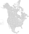
Fayil:North America second level political division 2.svg

Hoton asali (Fayil kin SVG, saƙar fikisal 512 x 596, girman fayil: 132 KB)

Wannan hoto yazo daga Wikimedia Commons kuma za'a iya amfani dashi a wasu projects. Anan kasa an nuna asalin bayanin shi

Taƙaici

Bayani
English: Map of North America and its second-level political divisions. Canadian provinces, US and Mexican states. Canada, Mexico, United States.

Non-contiguous parts of a states/provinces are "grouped" together with the main area of the state/provinces, so any state/provinces can be coloured in completion with one click anywhere on the state/provinces's area.

Also, all states/provinces have a "id" attached to them, making them easy to find. Select "find" and then enter in the state/provinces's ISO 3166-2 code in the "id" field to find it. The codes can be found here (Canada), here (USA) and here (Mexico).
Rana
Masomi

Canada and US map: BlankMap-USA-states-Canada-provinces, HI closer.svg by Lokal_Profil.
Mexico map: Mexico template.svg by Mario Fuente Cid
Combined by Alex Covarrubias.

 
The SVG code is valid.
 
This vector image was created with Inkscape, and then manually edited
.
 
W3C-validity not checked.
Marubucin Alex Covarrubias
Izini
(Sake amfani da wannan fayil)
w:en:Creative Commons
Jinginarwa Yada ahaka
This file is licensed under the Creative Commons Attribution-Share Alike 2.5 Generic license.
Za ka iya:
  • a raba – dan kwafa, yadawa da aika aikin
  • dan maimaita – dan daukar aikin
A karkashin wannan sharuddan
  • Jinginarwa – Dole ku bada jinjina da ta dace, samar da linki zuwa lasisin, da kuma bayyana ko kunyi sauyi. Zaku iya haka ta yadda ta dace, amma ba kowace hanya ba wanda zai nuna mai-lasisin yana goyon bayan ku ba ko goyon bayan amfanin da kuke yi ba.
  • Yada ahaka – Idan kuka maimaita, sabuntawa, ko kari akan wannan, dole ku bayar da gudunmuwar ku karkashin iri daya ko lasisi data dace kamar na asali.
Other versions

Derivative works of this file:

Take

Add a one-line explanation of what this file represents

Abubuwan da aka nuna a cikin wannan fayil

depicts Turanci

copyrighted Turanci

7 Oktoba 2007

Tarihin fayil

Ku latsa rana/lokaci ku ga fayil yadda yake a wannan lokaci

Rana/LokaciWadar sufaKusurwowiMa'aikaciBahasi
na yanzu01:51, 23 Nuwamba, 2020Wadar sufa ta zubin 01:51, 23 Nuwamba, 2020512 × 596 (132 KB)Ponderosapine210Added the prominent islands of Manitoulin (Ontario) and Isle Royale (Michigan) to the Great Lakes.
23:07, 1 ga Yuni, 2019Wadar sufa ta zubin 23:07, 1 ga Yuni, 2019512 × 596 (130 KB)Fluffy89502added territories, made DC visible, adjusted mexican borders
12:23, 4 ga Afirilu, 2014Wadar sufa ta zubin 12:23, 4 ga Afirilu, 20141,712 × 1,992 (270 KB)Lommesmade the borders between the mexican subdivisions the same size as their canadian / us counterparts.
23:23, 8 Disamba 2007Wadar sufa ta zubin 23:23, 8 Disamba 20071,712 × 1,992 (327 KB)Lokal ProfilCode cleanup
07:55, 7 Oktoba 2007Wadar sufa ta zubin 07:55, 7 Oktoba 20071,712 × 1,992 (342 KB)AlexCovarrubias== Summary == {{Information |Description=Map of North America and its second-level political divisions. Canadian provinces, US and Mexican states. Canada, Mexico, United States. |Source=Canada and US map by Alan Rockefeller. Mexico map by Alex Covarrubias

Babu shafuka da suke amfani da fayil din nan.

Amfanin fayil a ko'ina

bayannan meta