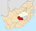
Fayil:Map of South Africa with Xhariep highlighted (2011).svg

Size of this PNG preview of this SVG file: 684 × 599 pixels. Wasu yarjejeniyoyi: 274 × 240 pixels | 548 × 480 pixels | 876 × 768 pixels | 1,168 × 1,024 pixels | 2,337 × 2,048 pixels | 809 × 709 pixels.
Hoton asali (Fayil kin SVG, saƙar fikisal 809 x 709, girman fayil: 497 KB)
Tarihin fayil
Ku latsa rana/lokaci ku ga fayil yadda yake a wannan lokaci
| Rana/Lokaci | Wadar sufa | Kusurwowi | Ma'aikaci | Bahasi | |
|---|---|---|---|---|---|
| na yanzu | 19:25, 2 Mayu 2011 |  | 809 × 709 (497 KB) | Htonl | == Summary == {{Information |Description ={{en|1=Map of district boundaries in South Africa, as they will be after the municipal elections of 18 May 2011, with the w:Xhariep District Municipality highli |
Amfani da fayil
Wadannan shafi na amfani wannan fayil:
Amfanin fayil a ko'ina
Wadannan sauran wikis suna amfani da fayil din anan
- Amfani a kan af.wikipedia.org
- Philippolis
- Trompsburg
- Rouxville
- Bethulie
- Wepener
- Zastron
- Jacobsdal
- Jagersfontein
- Koffiefontein
- Smithfield
- Dewetsdorp
- Fauresmith
- Edenburg
- Luckhoff
- Petrusburg
- Springfontein
- Reddersburg
- Van Stadensrus
- Gariepdam (dorp)
- Teisesville
- Saundershoogte
- Uitkoms
- Matlakeng
- Mofulatshepe
- Ratanang
- Sjabloonbespreking:Suid-Afrikaanse distriksmunisipaliteit navbox
- Bethanie, Vrystaat
- Qibing
- Roleleyathunya
- Ditlhake
- Bolokanang
- Rooibult
- Amfani a kan ceb.wikipedia.org
- Amfani a kan en.wikipedia.org
Duba ƙarin amfanin wannan fayil.
