File:Waterfalls of coo belgium.jpg

Yanayin wannan rigayi gani: 800 × 600 pixels. Wasu yarjejeniyoyi: 320 × 240 pixels | 640 × 480 pixels | 1,024 × 768 pixels.
Hoton asali (pikisal 1,024 × 768, girman fayil: 176 KB, irin MIME: image/jpeg)
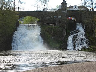
| Bayani | The waterfalls of coo |
| Rana | |
| Masomi | Aikin na |
| Marubucin | User:Boris23 |
| Camera location | | View this and other nearby images on: OpenStreetMap |
|---|
| I, the copyright holder of this work, release this work into the public domain. This applies worldwide. In some countries this may not be legally possible; if so: I grant anyone the right to use this work for any purpose, without any conditions, unless such conditions are required by law. |
Tarihin fayil
Ku latsa rana/lokaci ku ga fayil yadda yake a wannan lokaci
| Rana/Lokaci | Wadar sufa | Kusurwowi | Ma'aikaci | Bahasi | |
|---|---|---|---|---|---|
| na yanzu | 23:11, 30 Disamba 2004 | | 1,024 × 768 (176 KB) | Boris~commonswiki | {{GFDL}} |
Amfani da fayil
Wadannan shafi na amfani wannan fayil:
Amfanin fayil a ko'ina
Wadannan sauran wikis suna amfani da fayil din anan
- Amfani a kan br.wikipedia.org
- Amfani a kan ca.wikipedia.org
- Amfani a kan ceb.wikipedia.org
- Amfani a kan cs.wikipedia.org
- Amfani a kan de.wikipedia.org
- Amfani a kan de.wikivoyage.org
- Amfani a kan en.wikipedia.org
- Amfani a kan es.wikipedia.org
- Amfani a kan fr.wikipedia.org
- Amfani a kan fr.wikivoyage.org
- Amfani a kan hr.wikipedia.org
- Amfani a kan hu.wikipedia.org
- Amfani a kan incubator.wikimedia.org
- Amfani a kan it.wikipedia.org
- Amfani a kan ksh.wikipedia.org
- Amfani a kan lb.wikipedia.org
- Amfani a kan nl.wikipedia.org
- Amfani a kan pl.wikipedia.org
- Amfani a kan sk.wikipedia.org
- Amfani a kan ug.wikipedia.org
- Amfani a kan www.wikidata.org