Fayil:Sahel Map-Africa rough.png
Yanayin wannan rigayi gani: 800 × 370 pixels. Wasu yarjejeniyoyi: 320 × 148 pixels | 640 × 296 pixels | 1,024 × 474 pixels | 2,000 × 925 pixels.
Hoton asali (pikisal 2,000 × 925, girman fayil: 291 KB, irin MIME: image/png)
| Bayani |
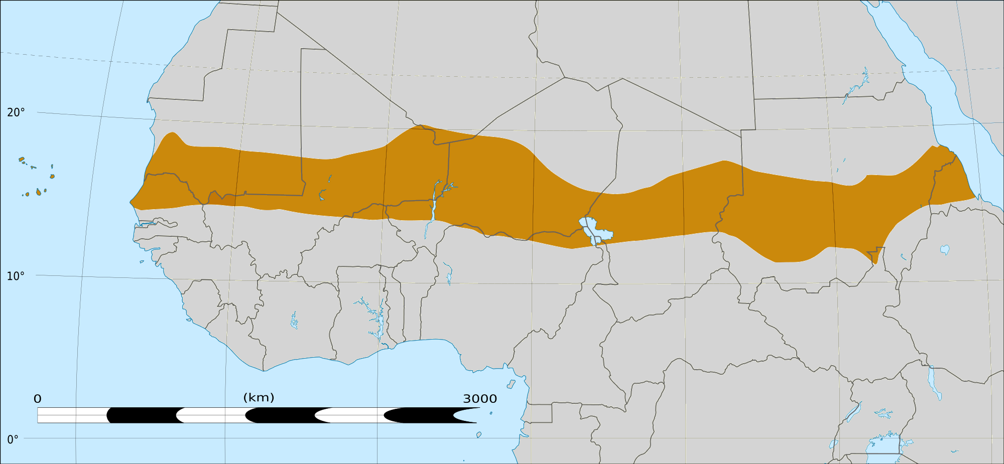
English: Map of Africa, with the Sahel highlighted in orange.
This is roughly the African land area between the lines of 200mm (north) and 600mm (south) mean 20th century annual rainfall. This is limited to land areas directly to the south of the Sahara desert and including the islands of Cape Verde, but not including other areas in Africa with the same rainfall statistics. This is one, but not the only, definition of the Sahel region. |
|||
| Rana | 20 Faburairu 2009 03:54 (UTC) | |||
| Masomi |
Felix Koenig: "created/photographed by myself (based on the existing blank map of Africa)"
|
|||
| Marubucin | ||||
| Other versions |
|


| This is a retouched picture, which means that it has been digitally altered from its original version. Modifications: Reproduced Sahel boundary from Map sahel.jpg on png map, cropped. The original can be viewed here: BlankMap-Africa2.png:
|
Lasisi
I, the copyright holder of this work, hereby publish it under the following licenses:

|
An bada damar a kofa, a yaɗa/ko sauya wannan kundi ƙarƙashin Lasisin GNU ta kyauta, Fitarwa na 1.2 ko duk wani fitarwa da zai biyo baya daga Gidauniyar Samar da Software ta Kyauta; ba tare da sauyin sashe ba, babu Rubutun Fuskar gaban shafi, kuma babu Rubutun bayan shafi. Kofi na lasisin na nan an sanya sa aciki ƙarƙashin sashen GNU Free Documentation License. |
This file is licensed under the Creative Commons Attribution-Share Alike Attribution-Share Alike 4.0 International, 3.0 Unported, 2.5 Generic, 2.0 Generic and 1.0 Generic license.
- Za ka iya:
- a raba – dan kwafa, yadawa da aika aikin
- dan maimaita – dan daukar aikin
- A karkashin wannan sharuddan
- Jinginarwa – Dole ku bada jinjina da ta dace, samar da linki zuwa lasisin, da kuma bayyana ko kunyi sauyi. Zaku iya haka ta yadda ta dace, amma ba kowace hanya ba wanda zai nuna mai-lasisin yana goyon bayan ku ba ko goyon bayan amfanin da kuke yi ba.
- Yada ahaka – Idan kuka maimaita, sabuntawa, ko kari akan wannan, dole ku bayar da gudunmuwar ku karkashin iri daya ko lasisi data dace kamar na asali.
Ku na iya zaɓan lasisin da kuke so.
|
|
An bada damar a kofa, a yaɗa/ko sauya wannan kundi ƙarƙashin Lasisin GNU ta kyauta, Fitarwa na 1.2 ko duk wani fitarwa da zai biyo baya daga Gidauniyar Samar da Software ta Kyauta; ba tare da sauyin sashe ba, babu Rubutun Fuskar gaban shafi, kuma babu Rubutun bayan shafi. Kofi na lasisin na nan an sanya sa aciki ƙarƙashin sashen GNU Free Documentation License. |
Original upload log
This image is a derivative work of the following images:
- File:Map_sahel.jpg licensed with GFDL
- 2005-05-30T17:36:46Z King 800x800 (89588 Bytes) one moment please
- File:BlankMap-Africa2.png licensed with Cc-by-sa-3.0,2.5,2.0,1.0, GFDL
- 2008-03-08T18:02:20Z Sadalmelik 1754x1546 (51013 Bytes) {{Information |Description=Blank map of Africa |Source=self-made |Date=2008-03-08 |Author= [[User:Sadalmelik|Sadalmelik]] |Permission= |other_versions= }} [[Category:Blank maps of Africa]]
Uploaded with derivativeFX
Tarihin fayil
Ku latsa rana/lokaci ku ga fayil yadda yake a wannan lokaci
| Rana/Lokaci | Wadar sufa | Kusurwowi | Ma'aikaci | Bahasi | |
|---|---|---|---|---|---|
| na yanzu | 16:15, 17 ga Maris, 2018 | | 2,000 × 925 (291 KB) | Maphobbyist | South Sudan border |
| 04:02, 20 ga Faburairu, 2009 |  | 1,384 × 658 (29 KB) | T L Miles | {{Information |Description=*Description: A map of Africa: the Sahel highlighted in orange. Note, this is ROUGHLY the African land area between the lines of 200mm (north) and 600mm (south) mean 20th century annual rainfall. This is limited to land areas d |
Amfani da fayil
Wadannan shafi na amfani wannan fayil:
Amfanin fayil a ko'ina
Wadannan sauran wikis suna amfani da fayil din anan
- Amfani a kan af.wikipedia.org
- Amfani a kan als.wikipedia.org
- Amfani a kan ar.wikipedia.org
- Amfani a kan az.wikipedia.org
- Amfani a kan bcl.wikipedia.org
- Amfani a kan be.wikipedia.org
- Amfani a kan bg.wikipedia.org
- Amfani a kan bn.wikipedia.org
- Amfani a kan br.wikipedia.org
- Amfani a kan ca.wikipedia.org
- Amfani a kan ce.wikipedia.org
- Amfani a kan da.wikipedia.org
- Amfani a kan en.wikipedia.org
- Amfani a kan eu.wikipedia.org
- Amfani a kan fa.wikipedia.org
- Amfani a kan fi.wiktionary.org
- Amfani a kan fr.wikipedia.org
- Amfani a kan fr.wikinews.org
- Amfani a kan ig.wikipedia.org
- Amfani a kan incubator.wikimedia.org
- Amfani a kan it.wikipedia.org
- Amfani a kan ja.wikipedia.org
- Amfani a kan ka.wikipedia.org
- Amfani a kan ko.wikipedia.org
- Amfani a kan mg.wikipedia.org
- Amfani a kan mk.wikipedia.org
- Amfani a kan ml.wikipedia.org
Duba ƙarin amfanin wannan fayil.