File:Kagbeni Mustang-WLV-0741.jpg

Yanayin wannan rigayi gani: 800 × 533 pixels. Wasu yarjejeniyoyi: 320 × 213 pixels | 640 × 427 pixels | 1,024 × 683 pixels | 1,280 × 853 pixels | 2,560 × 1,706 pixels | 5,027 × 3,351 pixels.
Hoton asali (pikisal 5,027 × 3,351, girman fayil: 11.12 MB, irin MIME: image/jpeg)
Taƙaici
| Bayani |
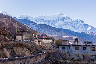
English: Kagbeni is a village in the Upper Mustang of the Himalayas, in Nepal, located in the valley of the Kali Gandaki River. Administratively, Kagbeni is a Village Development Committee in Mustang District in the Dhawalagiri Zone of northern Nepal. At the time of the 1991 Nepal census it had a population of 1200 people residing in 260 individual households. [1] It lies on the trail from Jomsom to the royal capital Lo Manthang, near the junction with the trail to Muktinath. |
|||||||||||||||||||||||
| Rana | ||||||||||||||||||||||||
| Masomi | Aikin na | |||||||||||||||||||||||
| Marubucin |
|
|||||||||||||||||||||||

| Camera location | | View this and other nearby images on: OpenStreetMap |
|---|
Assessment
|
Lasisi
|

This file is licensed under the Creative Commons Attribution-Share Alike 4.0 International license.
Jinginarwa: Bijay chaurasia
- Za ka iya:
- a raba – dan kwafa, yadawa da aika aikin
- dan maimaita – dan daukar aikin
- A karkashin wannan sharuddan
- Jinginarwa – Dole ku bada jinjina da ta dace, samar da linki zuwa lasisin, da kuma bayyana ko kunyi sauyi. Zaku iya haka ta yadda ta dace, amma ba kowace hanya ba wanda zai nuna mai-lasisin yana goyon bayan ku ba ko goyon bayan amfanin da kuke yi ba.
- Yada ahaka – Idan kuka maimaita, sabuntawa, ko kari akan wannan, dole ku bayar da gudunmuwar ku karkashin iri daya ko lasisi data dace kamar na asali.

|
This image was uploaded as part of Wiki Loves Villages.
|
Tarihin fayil
Ku latsa rana/lokaci ku ga fayil yadda yake a wannan lokaci
| Rana/Lokaci | Wadar sufa | Kusurwowi | Ma'aikaci | Bahasi | |
|---|---|---|---|---|---|
| na yanzu | 10:13, 3 ga Yuni, 2018 | | 5,027 × 3,351 (11.12 MB) | Bijay Chaurasia | reupload |
| 14:04, 27 ga Janairu, 2018 |  | 5,027 × 3,351 (1.91 MB) | Bijay Chaurasia | User created page with UploadWizard |
Amfani da fayil
Wadannan shafi na amfani wannan fayil:
Amfanin fayil a ko'ina
Wadannan sauran wikis suna amfani da fayil din anan
- Amfani a kan de.wikipedia.org
- Amfani a kan en.wikipedia.org
- Amfani a kan fr.wikipedia.org
- Amfani a kan hi.wikipedia.org
- Amfani a kan mai.wikipedia.org
- Amfani a kan ne.wikipedia.org
- Amfani a kan pt.wikipedia.org
- Amfani a kan ta.wikipedia.org