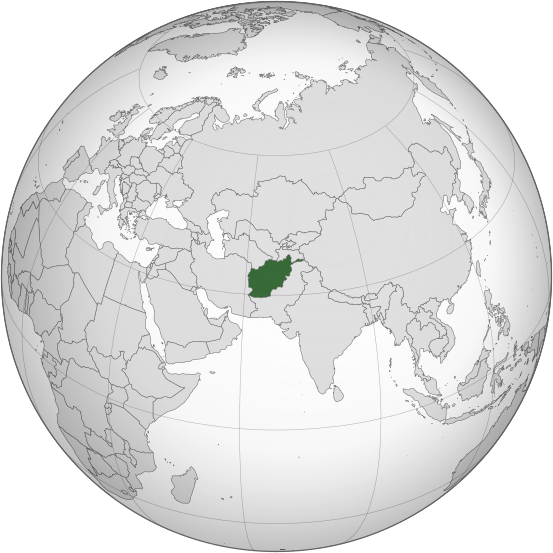
File:Afghanistan (orthographic projection).svg

Size of this PNG preview of this SVG file: 553 × 553 pixels. Wasu yarjejeniyoyi: 240 × 240 pixels | 480 × 480 pixels | 768 × 768 pixels | 1,024 × 1,024 pixels | 2,048 × 2,048 pixels.
Hoton asali (Fayil kin SVG, saƙar fikisal 553 x 553, girman fayil: 298 KB)
.svg)
Taƙaici
| Bayani |
اردو: طرحی متعامد از افغانستان |
| Rana | |
| Masomi | Own work based on: India (orthographic projection).svg by Ssolbergj |
| Marubucin | Shahid Parvez |
| SVG genesis |
.svg)
Lasisi
The map has been created with the Generic Mapping Tools: https://www.generic-mapping-tools.org/ using one or more of these public-domain datasets for the relief:
|

|
An bada damar a kofa, a yaɗa/ko sauya wannan kundi ƙarƙashin Lasisin GNU ta kyauta, Fitarwa na 1.2 ko duk wani fitarwa da zai biyo baya daga Gidauniyar Samar da Software ta Kyauta; ba tare da sauyin sashe ba, babu Rubutun Fuskar gaban shafi, kuma babu Rubutun bayan shafi. Kofi na lasisin na nan an sanya sa aciki ƙarƙashin sashen GNU Free Documentation License. |
Original upload log
Transferred from en.wikipedia to Commons by Cirt using CommonsHelper.
The original description page was here. All following user names refer to en.wikipedia.
- 2009-10-05 17:28 Parvez gsm 541×541× (517730 bytes) {{Information |Description = Afghanistan orthographic_projection |Source = I have created this work entirely by myself. |Date = October 5 |Author = Shahid Parvez |other_versions = }}
Tarihin fayil
Ku latsa rana/lokaci ku ga fayil yadda yake a wannan lokaci
| Rana/Lokaci | Wadar sufa | Kusurwowi | Ma'aikaci | Bahasi | |
|---|---|---|---|---|---|
| na yanzu | 14:46, 27 ga Yuli, 2019 | | 553 × 553 (298 KB) | Cerebellum | Revert to prior version, please provide a source for those territorial claims |
| 10:29, 26 ga Yuli, 2019 |  | 720 × 720 (384 KB) | Lakshmisreekanth | Updated color | |
| 17:00, 25 ga Yuli, 2019 |  | 720 × 727 (397 KB) | Lakshmisreekanth | Added claimed regions | |
| 23:36, 16 ga Maris, 2015 |  | 553 × 553 (298 KB) | Flappiefh | Removed Somaliland and Kosovo. Separated Western Sahara and Morroco. | |
| 12:43, 4 ga Augusta, 2013 |  | 553 × 553 (302 KB) | Flappiefh | Added South Sudan. The map is now centered on Afghanistan. | |
| 22:45, 20 Nuwamba, 2009 |  | 541 × 541 (506 KB) | File Upload Bot (Magnus Manske) | {{BotMoveToCommons|en.wikipedia|year={{subst:CURRENTYEAR}}|month={{subst:CURRENTMONTHNAME}}|day={{subst:CURRENTDAY}}}} {{Information |Description={{en|Afghanistan orthographic_projection}} |Source=Transferred from [http://en.wikipedia.org en.wikipedia]; |
Amfani da fayil
Wadannan shafi na amfani wannan fayil:
Amfanin fayil a ko'ina
Wadannan sauran wikis suna amfani da fayil din anan
- Amfani a kan ady.wikipedia.org
- Amfani a kan af.wikipedia.org
- Amfani a kan ami.wikipedia.org
- Amfani a kan arc.wikipedia.org
- Amfani a kan ar.wikipedia.org
- Amfani a kan arz.wikipedia.org
- Amfani a kan ast.wikipedia.org
- Amfani a kan as.wikipedia.org
- Amfani a kan av.wikipedia.org
- Amfani a kan awa.wikipedia.org
- Amfani a kan azb.wikipedia.org
- Amfani a kan az.wikipedia.org
- Amfani a kan az.wiktionary.org
- Amfani a kan ba.wikipedia.org
- Amfani a kan bbc.wikipedia.org
- Amfani a kan be-tarask.wikipedia.org
- Amfani a kan be.wikipedia.org
- Amfani a kan bg.wikipedia.org
- Amfani a kan bh.wikipedia.org
- Amfani a kan bi.wikipedia.org
- Amfani a kan bn.wikipedia.org
- Amfani a kan bn.wikivoyage.org
- Amfani a kan br.wikipedia.org
Duba ƙarin amfanin wannan fayil.
.svg)
.svg)